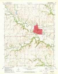
1971 Map of Eureka
USGS Topo · Published 1973About this map
The Fall River carves a winding path through the center of this Greenwood County landscape, framing the development of Eureka during the early 1970s. This survey captures a crossroads of regional infrastructure where the Atchison Topeka and Santa Fe and Missouri Pacific railroads intersect near the heart of town. The map provides a detailed view of local civic life, noting the Po (Post Office), CH (Courthouse), and an array of educational institutions including Sacred Heart Sch and the North Side Sch.
Find a feature on this map
38 named features on this map. Tap any name to fly to it.
Don’t see what you’re looking for? This feature index may not catch every label — zoom into the map to look around manually.
Map Details
Editions of this 1971 Eureka Map
This is the sole edition of this map. No revisions or reprints were ever made.
Other maps of this area

1885 · Eureka
USGS Topo · 1:125,000

1888 · Eureka
USGS Topo · 1:125,000

1894 · Eureka
USGS Topo · 1:125,000

1939 · Severy
USGS Topo · 1:62,500

1941 · Severy
USGS Topo · 1:62,500

1955 · Wichita
USGS Topo · 1:250,000

1958 · Wichita
USGS Topo · 1:250,000

1964 · Piedmont NW
USGS Topo · 1:24,000
1964 · Piedmont NE
USGS Topo · 1:24,000
1971 · Reece
USGS Topo · 1:24,000