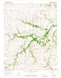
1964 Map of Piedmont NE
USGS Topo · Published 1965About this map
The St Louis San Francisco railroad cuts across the southern edge of this Greenwood County landscape, marking the transit corridor through the Flint Hills region in the mid-1960s. The topography is defined by the dendritic drainage patterns of the Fall River and its numerous tributaries, including Tadpole Creek and Honey Cr. High ground is represented by the open stretches of Spring Creek and Twin Grove. Genealogists and local historians will find several key landmarks, such as Pleasant View Cem situated near the confluence of the North Branch Otter Creek and South Branch Otter Creek. Evidence of local industry appears in the form of several Quarries located in the eastern portion of the survey. The map also includes the Piedmont Cem, providing a precise look at the rural settlement and cemetery locations before modern land-use changes.
Find a feature on this map
16 named features on this map. Tap any name to fly to it.
Don’t see what you’re looking for? This feature index may not catch every label — zoom into the map to look around manually.
Map Details
Editions of this 1964 Piedmont NE Map
This is the sole edition of this map. No revisions or reprints were ever made.
Other maps of this area

1885 · Eureka
USGS Topo · 1:125,000

1888 · Eureka
USGS Topo · 1:125,000

1894 · Eureka
USGS Topo · 1:125,000

1939 · Severy
USGS Topo · 1:62,500

1941 · Severy
USGS Topo · 1:62,500

1955 · Wichita
USGS Topo · 1:250,000

1958 · Wichita
USGS Topo · 1:250,000
1964 · Piedmont SW
USGS Topo · 1:24,000

1964 · Piedmont NW
USGS Topo · 1:24,000
1964 · Piedmont
USGS Topo · 1:24,000