1940s Maps of Jarbalo, Kansas
Explore 1 historic maps of Jarbalo from the 1940s. These maps offer a rare glimpse into what life looked like during the 1940s — showing old roads, neighborhoods, homes, and landmarks that have changed or disappeared over time.
Whether you're researching your family's past, planning a metal detecting trip, or studying how Jarbalo's landscape evolved across the 1940s, these high-resolution maps are a powerful tool for exploring the history of this region.
- Focus on a specific era: All maps on this page are from the 1940s, giving you a focused view of this time period.
- See what’s changed: Compare century-old streets, trails, and buildings to today's modern landscape using overlays and satellite layers.
- Research with precision: Use these maps for genealogy, historical research, land use analysis, or educational projects.
- View, download, or print: Maps are fully viewable online in high resolution, and can be downloaded or printed for your own records.
Start exploring Jarbalo's history through authentic maps from the 1940s. This is your window into the past.
Jarbalo, KS maps
(1)- 1948 Map of Jarbalo, 1967 Print
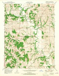 1948 Jarbalo1967 Print · USGSLeavenworth County agricultural life is preserved here in the late 1940s, when small rural townships were dotted with family-named schools and creek-side cemeteries. You can trace the Union Pacific rail corridor or locate vanished local landmarks like Friendship Valley School, Jarbalo, and Eagle Cemetery.2 unique versions available
End of results
Showing maps 1-1 of 1
Top cities near Jarbalo
- Kansas City historical maps
- Olathe historical maps
- Lawrence historical maps
- Shawnee historical maps
- Lenexa historical maps
- Leavenworth historical maps
See more
Frequently asked questions
- What are the different types of historical maps available for Jarbalo?
- What is the oldest map of Jarbalo?
- Where can I purchase historical maps of Jarbalo for my home or office?
- Where can I download high-res historical maps of Jarbalo?
- Are there historical topographic maps available for Jarbalo?
- Is there historical aerial imagery available for Jarbalo?
- Where are historical maps of Jarbalo sourced from?