1960s Maps of McPherson, Kansas
Explore 3 historic maps of McPherson from the 1960s. These maps offer a rare glimpse into what life looked like during the 1960s — showing old roads, neighborhoods, homes, and landmarks that have changed or disappeared over time.
Whether you're researching your family's past, planning a metal detecting trip, or studying how McPherson's landscape evolved across the 1960s, these high-resolution maps are a powerful tool for exploring the history of this region.
- Focus on a specific era: All maps on this page are from the 1960s, giving you a focused view of this time period.
- See what’s changed: Compare century-old streets, trails, and buildings to today's modern landscape using overlays and satellite layers.
- Research with precision: Use these maps for genealogy, historical research, land use analysis, or educational projects.
- View, download, or print: Maps are fully viewable online in high resolution, and can be downloaded or printed for your own records.
Start exploring McPherson's history through authentic maps from the 1960s. This is your window into the past.
McPherson, KS maps
(3)- 1965 Map of Mc Pherson South, 1966 Print
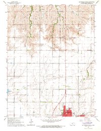
 1965 Mc Pherson South1966 Print · USGSMcPherson thrived as a center for education and industry in the mid-1960s, surrounded by vast Kansas agricultural lands. Genealogists and historians can trace the development of McPherson College or locate family sites near Groveland and the McPherson Cemetery.3 unique versions available
 - 1965 Map of Mc Pherson SE, 1966 Print
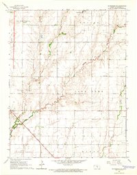 1965 Mc Pherson SE1966 Print · USGSMcPherson County agricultural and oil lands are captured here in the mid-sixties, south of the county seat. Researchers can trace the legacy of rural communities through the Sunflower Sch, the Ritz Canton Oil Field, and the rail stop at Elyria.4 unique versions available
 - 1965 Map of Mc Pherson North, 1966 Print
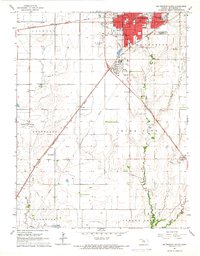
 1965 Mc Pherson North1966 Print · USGSMid-century Kansas comes to life as the city of McPherson expands amid a network of rural schoolhouses and active rail lines. Researchers can trace the layout of the Lincoln Sch, locate the old Drive-in Theater, and follow the Union Pacific railroad through Johnstown.3 unique versions available
End of results
Showing maps 1-3 of 3
Top cities near McPherson
- Hesston historical maps
- Lindsborg historical maps
- Moundridge historical maps
- Medora historical maps
- Inman historical maps
- Buhler historical maps
See more
Frequently asked questions
- What are the different types of historical maps available for McPherson?
- What is the oldest map of McPherson?
- Where can I purchase historical maps of McPherson for my home or office?
- Where can I download high-res historical maps of McPherson?
- Are there historical topographic maps available for McPherson?
- Is there historical aerial imagery available for McPherson?
- Where are historical maps of McPherson sourced from?