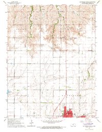
1965 Map of Mc Pherson North
USGS Topo · Published 1966About this map
The city of McPherson serves as the focal point for this mid-1960s landscape, where urban expansion meets a grid of rural school districts and family farms. The map documents several educational landmarks essential to local genealogy, including Sunny Slope Sch, New Gottland Sch, and Center View Sch, highlighting the importance of neighborhood schooling during this era. The terrain is defined by the winding paths of Sharps Creek and Dry Turkey Creek, which cut through the agricultural townships of Harper and New Gottland.
Find a feature on this map
28 named features on this map. Tap any name to fly to it.
Don’t see what you’re looking for? This feature index may not catch every label — zoom into the map to look around manually.
Map Details
Editions of this 1965 Mc Pherson North Map
3 editions found
Other maps of this area

1891 · Hutchinson
USGS Topo · 1:125,000

1892 · Salina
USGS Topo · 1:125,000

1893 · Hutchinson
USGS Topo · 1:125,000

1942 · Salina
USGS Topo · 1:125,000

1955 · Hutchinson
USGS Topo · 1:250,000

1959 · Hutchinson
USGS Topo · 1:250,000

1964 · Marquette
USGS Topo · 1:24,000

1964 · Conway
USGS Topo · 1:24,000

1965 · Mc Pherson South
USGS Topo · 1:24,000

1965 · Galva
USGS Topo · 1:24,000