1980s Maps of Miami County, Kansas
Explore 4 historic maps of Miami County from the 1980s. These maps offer a rare glimpse into what life looked like during the 1980s — showing old roads, neighborhoods, homes, and landmarks that have changed or disappeared over time.
Whether you're researching your family's past, planning a metal detecting trip, or studying how Miami County's landscape evolved across the 1980s, these high-resolution maps are a powerful tool for exploring the history of this region.
- Focus on a specific era: All maps on this page are from the 1980s, giving you a focused view of this time period.
- See what’s changed: Compare century-old streets, trails, and buildings to today's modern landscape using overlays and satellite layers.
- Research with precision: Use these maps for genealogy, historical research, land use analysis, or educational projects.
- View, download, or print: Maps are fully viewable online in high resolution, and can be downloaded or printed for your own records.
Start exploring Miami County's history through authentic maps from the 1980s. This is your window into the past.
Miami County, KS maps
(4)- 1981 Map of Butler
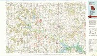 1981 Butler1981 Print · USGSWestern Missouri and eastern Kansas settlements are documented here in the early eighties, as the river valleys were transitioning into major wildlife management areas. Genealogists can locate family names near Greenlawn Cem or trace the development of towns like Butler, Osawatomie, and Appleton City.
 - 1983 Map of Olathe, 1984 Print
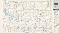
 1983 Olathe1984 Print · USGSThe Kansas-Missouri borderlands hum with suburban growth and historic transit routes in the early eighties. Researchers can trace the Santa Fe Trail across a landscape featuring Richards-Gebaur Air Force Base and Hillsdale Lake.
 - 1983 Map of Lawrence, 1984 Print
 1983 Lawrence1984 Print · USGSEastern Kansas in the early eighties shows a landscape of growing reservoirs and historic rail towns. Genealogists and historians can trace routes through Topeka and Ottawa, or locate smaller sites like Highland Cem and the settlement of Vassar.
 - 1985 Map of Garnett
 1985 Garnett1985 Print · USGSAnderson County and its neighbors in the mid-eighties show a landscape of rising reservoirs and enduring rail towns. Genealogists and historians can trace the transition from rail to highway at Beto Junction or locate heritage sites like Silkville and Neosho Rapids.
End of results
Showing maps 1-4 of 4
Top cities of Miami County
- Paola historical maps
- Osawatomie historical maps
- Louisburg historical maps
- Wea historical maps
- Stanton historical maps
- Fontana historical maps
Frequently asked questions
- What are the different types of historical maps available for Miami County?
- What is the oldest map of Miami County?
- Where can I purchase historical maps of Miami County for my home or office?
- Where can I download high-res historical maps of Miami County?
- Are there historical topographic maps available for Miami County?
- Is there historical aerial imagery available for Miami County?
- Where are historical maps of Miami County sourced from?