1970s Maps of Mitchell County, Kansas
Explore 2 historic maps of Mitchell County from the 1970s. These maps offer a rare glimpse into what life looked like during the 1970s — showing old roads, neighborhoods, homes, and landmarks that have changed or disappeared over time.
Whether you're researching your family's past, planning a metal detecting trip, or studying how Mitchell County's landscape evolved across the 1970s, these high-resolution maps are a powerful tool for exploring the history of this region.
- Focus on a specific era: All maps on this page are from the 1970s, giving you a focused view of this time period.
- See what’s changed: Compare century-old streets, trails, and buildings to today's modern landscape using overlays and satellite layers.
- Research with precision: Use these maps for genealogy, historical research, land use analysis, or educational projects.
- View, download, or print: Maps are fully viewable online in high resolution, and can be downloaded or printed for your own records.
Start exploring Mitchell County's history through authentic maps from the 1970s. This is your window into the past.
Mitchell County, KS maps
(2)- 1978 Map of Tipton, 1979 Print
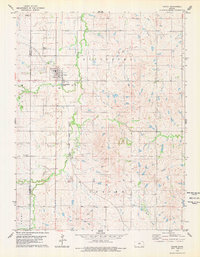 1978 Tipton1979 Print · USGSThe northern Kansas prairie around Tipton is captured here in the late seventies as the rail-and-ranching economy remained firmly in place. Genealogists can locate family plots at St Boniface Cem and Union Cem or trace the Atchison Topeka and Santa Fe line.
 - 1978 Map of Blue Hill, 1979 Print
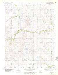 1978 Blue Hill1979 Print · USGSMitchell County farmland is documented here in the late seventies, showing the rural community and shifting terrain of north-central Kansas. Researchers can locate family sites near Rose Valley Cem or trace the paths of Salt Creek and Walnut Creek.
End of results
Showing maps 1-2 of 2
Top cities of Mitchell County
- Beloit historical maps
- Cawker City historical maps
- Glen Elder historical maps
- Tipton historical maps
- Asherville historical maps
- Solomon Rapids historical maps
See more
Frequently asked questions
- What are the different types of historical maps available for Mitchell County?
- What is the oldest map of Mitchell County?
- Where can I purchase historical maps of Mitchell County for my home or office?
- Where can I download high-res historical maps of Mitchell County?
- Are there historical topographic maps available for Mitchell County?
- Is there historical aerial imagery available for Mitchell County?
- Where are historical maps of Mitchell County sourced from?