1950s Maps of Mitchell County, Kansas
Explore 11 historic maps of Mitchell County from the 1950s. These maps offer a rare glimpse into what life looked like during the 1950s — showing old roads, neighborhoods, homes, and landmarks that have changed or disappeared over time.
Whether you're researching your family's past, planning a metal detecting trip, or studying how Mitchell County's landscape evolved across the 1950s, these high-resolution maps are a powerful tool for exploring the history of this region.
- Focus on a specific era: All maps on this page are from the 1950s, giving you a focused view of this time period.
- See what’s changed: Compare century-old streets, trails, and buildings to today's modern landscape using overlays and satellite layers.
- Research with precision: Use these maps for genealogy, historical research, land use analysis, or educational projects.
- View, download, or print: Maps are fully viewable online in high resolution, and can be downloaded or printed for your own records.
Start exploring Mitchell County's history through authentic maps from the 1950s. This is your window into the past.
Mitchell County, KS maps
(11)- 1952 Map of Glasco SW, 1954 Print
 1952 Glasco SW1954 Print · USGSThe Solomon River valley in the early fifties shows a rural Kansas landscape of small townships and family burial grounds. Local researchers can trace the locations of Bohemian Hall, Coursen Grove School No 2, and the path of the Union Pacific railroad.2 unique versions available
 - 1953 Map of Solomon Rapids, 1954 Print
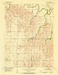
 1953 Solomon Rapids1954 Print · USGSMitchell County farmland surrounds the winding Solomon River in the early fifties, showcasing a landscape of rural schoolhouses and rail siding. Genealogists can locate Hopewell Ch, the Pleasant Valley Cem, and long-standing schools like Roundtop Sch.
 - 1953 Map of Waconda Springs, 1954 Print
 1953 Waconda Springs1954 Print · USGSMitchell County in the early fifties shows the Solomon River valley just before the landscape was transformed by reservoir construction. Genealogists and researchers can locate Waconda Springs, the St Peter and Paul Cem, and the rural Town Hall at the heart of Carr Creek.4 unique versions available
 - 1953 Map of Simpson, 1954 Print
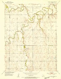
 1953 Simpson1954 Print · USGSThe Mitchell County countryside near the Solomon River comes into focus in the early fifties during a period of modern infrastructure expansion. Genealogists and local historians can trace family ties at Asherville Cem and Mcbride Cem or follow the Union Pacific rail line.2 unique versions available
 - 1953 Map of Glen Elder South, 1954 Print
 1953 Glen Elder South1954 Print · USGSMitchell County farmland in the early fifties was centered on the river-and-rail hub of Glen Elder. Genealogists and local historians can trace rural school districts at Naomi Sch and Grellett Sch or locate family plots at Fairview Cem and Excelsior Cem.3 unique versions available
 - 1953 Map of Beloit, 1954 Print
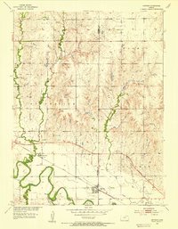
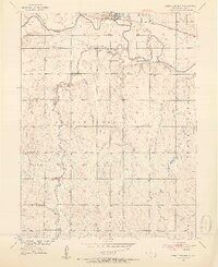
 1953 Beloit1954 Print · USGSBeloit and its surrounding river valley are captured here at mid-century, showing a landscape defined by rail lines and rural schools. Genealogists and local historians can locate specific landmarks like the State Girls School, Elmwood Cem, and Hyde Sch.2 unique versions available
 - 1955 Map of Manhattan, 1964 Print
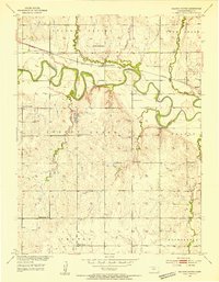
 1955 Manhattan1964 Print · USGSNorth Central Kansas is captured here in the mid-fifties, just as major flood control projects began reshaping the river valleys. Genealogists can locate family sites near St. Joseph Church, Sunset Cemetery, or along the busy tracks of the Rock Island RR.4 unique versions available
 - 1955 Map of Beloit, 1971 Print
 1955 Beloit1971 Print · USGSNorth Central Kansas in the mid-fifties shows a landscape of river-valley agriculture and expanding water infrastructure. Genealogists can trace the rail lines of the Union Pacific through towns like Nicodemus, Cawker City, and the State Sanatorium.3 unique versions available
 - 1956 Map of Manhattan
 1956 Manhattan1956 Print · USGSNorth-central Kansas in the mid-fifties reveals a landscape defined by the convergence of the Republican River and Smoky Hill River. Historians can trace the rail corridors of the Union Pacific RR and Missouri Pacific RR through towns like Manhattan and Clay Center.
 - 1957 Map of Manhattan
 1957 Manhattan1957 Print · USGSNortheast Kansas in the mid-1950s reveals a landscape of expanding military installations and new water projects. Genealogists and historians can trace the rail-to-river economy through the Union Pacific RR and old settlements like Clay Center or Marysville.
 - 1959 Map of Beloit
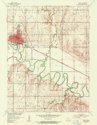
 1959 Beloit1959 Print · USGSNorth Central Kansas at mid-century reveals a landscape shaped by river valleys and the expansion of massive water reservoirs. Genealogists and historians can trace the rail-town connections of Beloit and Norton or locate the site of the new Webster Dam.3 unique versions available
End of results
Showing maps 1-11 of 11
Top cities of Mitchell County
- Beloit historical maps
- Cawker City historical maps
- Glen Elder historical maps
- Tipton historical maps
- Asherville historical maps
- Solomon Rapids historical maps
See more
Frequently asked questions
- What are the different types of historical maps available for Mitchell County?
- What is the oldest map of Mitchell County?
- Where can I purchase historical maps of Mitchell County for my home or office?
- Where can I download high-res historical maps of Mitchell County?
- Are there historical topographic maps available for Mitchell County?
- Is there historical aerial imagery available for Mitchell County?
- Where are historical maps of Mitchell County sourced from?