1980s Maps of Mitchell County, Kansas
Explore 4 historic maps of Mitchell County from the 1980s. These maps offer a rare glimpse into what life looked like during the 1980s — showing old roads, neighborhoods, homes, and landmarks that have changed or disappeared over time.
Whether you're researching your family's past, planning a metal detecting trip, or studying how Mitchell County's landscape evolved across the 1980s, these high-resolution maps are a powerful tool for exploring the history of this region.
- Focus on a specific era: All maps on this page are from the 1980s, giving you a focused view of this time period.
- See what’s changed: Compare century-old streets, trails, and buildings to today's modern landscape using overlays and satellite layers.
- Research with precision: Use these maps for genealogy, historical research, land use analysis, or educational projects.
- View, download, or print: Maps are fully viewable online in high resolution, and can be downloaded or printed for your own records.
Start exploring Mitchell County's history through authentic maps from the 1980s. This is your window into the past.
Mitchell County, KS maps
(4)- 1985 Map of Beloit
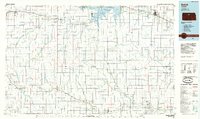 1985 Beloit1985 Print · USGSNorth Central Kansas in the mid-eighties shows a landscape shaped by the Solomon and Saline rivers and the massive Waconda Lake. Researchers can trace the routes of the Missouri Pacific RR and locate rural landmarks like the State Girls School and Denmark.2 unique versions available
 - 1985 Map of Clay Center
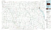 1985 Clay Center1985 Print · USGSThe river valleys of North Central Kansas appear here in the mid-eighties, showing the region's agricultural layout and the rise of Milford Lake. Researchers can trace old township connections through settlements like Delphos, Idana, and Summerville.2 unique versions available
 - 1985 Map of Concordia
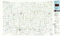 1985 Concordia1985 Print · USGSNorth Central Kansas in the mid-eighties shows a robust agricultural and rail corridor centered on the Republican River. Genealogists and historians can trace rail lines and community centers like the St Joseph Ch, Belleville Cem, and Cloud County Comm College.2 unique versions available
 - 1985 Map of Smith Center
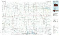 1985 Smith Center1985 Print · USGSNorth Central Kansas in the mid-eighties shows a landscape of small agricultural hubs like Smith Center and Mankato linked by the Missouri Pacific line. Researchers can locate the Geographic Center of 48 States and trace family roots near Fairview Cem or along Waconda Lake.2 unique versions available
End of results
Showing maps 1-4 of 4
Top cities of Mitchell County
- Beloit historical maps
- Cawker City historical maps
- Glen Elder historical maps
- Tipton historical maps
- Asherville historical maps
- Solomon Rapids historical maps
See more
Frequently asked questions
- What are the different types of historical maps available for Mitchell County?
- What is the oldest map of Mitchell County?
- Where can I purchase historical maps of Mitchell County for my home or office?
- Where can I download high-res historical maps of Mitchell County?
- Are there historical topographic maps available for Mitchell County?
- Is there historical aerial imagery available for Mitchell County?
- Where are historical maps of Mitchell County sourced from?