1970s Maps of Montgomery County, Kansas
Explore 4 historic maps of Montgomery County from the 1970s. These maps offer a rare glimpse into what life looked like during the 1970s — showing old roads, neighborhoods, homes, and landmarks that have changed or disappeared over time.
Whether you're researching your family's past, planning a metal detecting trip, or studying how Montgomery County's landscape evolved across the 1970s, these high-resolution maps are a powerful tool for exploring the history of this region.
- Focus on a specific era: All maps on this page are from the 1970s, giving you a focused view of this time period.
- See what’s changed: Compare century-old streets, trails, and buildings to today's modern landscape using overlays and satellite layers.
- Research with precision: Use these maps for genealogy, historical research, land use analysis, or educational projects.
- View, download, or print: Maps are fully viewable online in high resolution, and can be downloaded or printed for your own records.
Start exploring Montgomery County's history through authentic maps from the 1970s. This is your window into the past.
Montgomery County, KS maps
(4)- 1972 Map of Elliott, 1974 Print
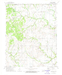 1972 Elliott1974 Print · USGSThe Oklahoma-Kansas borderlands near the start of the seventies show a landscape of active resource extraction and rural settlement. Researchers can trace the rail lines of the Missouri Pacific and locate family landmarks like Steward Cem and Pleasant Valley Ch.
 - 1972 Map of Wann, 1974 Print
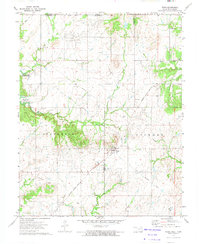 1972 Wann1974 Print · USGSNortheastern Oklahoma and the Kansas borderlands appear in the early seventies during the development of a major reservoir project. Genealogists and historians can locate family landmarks like the Patrick Cem and trace former rail lines like the Missouri - Kansas - Texas Railroad Grade.
 - 1972 Map of South Coffeyville, 1974 Print
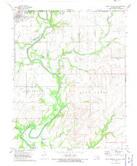 1972 South Coffeyville1974 Print · USGSSouth Coffeyville and the Verdigris River valley are shown here in the early seventies as the river winds toward the Oologah Lake reservoir. Researchers can trace rural lineages at Melton Cem and Hickory Creek Cem or locate old industrial sites like the Gravel Pits and Oil Wells.2 unique versions available
 - 1972 Map of Copan, 1974 Print
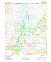 1972 Copan1974 Print · USGSNorthern Washington County and the Kansas borderlands appear here in the early seventies during the construction of the Copan Dam. Genealogists and historians can trace the original course of the Little Caney River before the reservoir, locating Owen, the Pleasant Grove Ch, and the Atchison Topeka and Santa Fe rail line.2 unique versions available
End of results
Showing maps 1-4 of 4
Top cities of Montgomery County
- Coffeyville historical maps
- Independence historical maps
- Cherryvale historical maps
- Caney historical maps
- Sycamore historical maps
- Dearing historical maps
See more
Frequently asked questions
- What are the different types of historical maps available for Montgomery County?
- What is the oldest map of Montgomery County?
- Where can I purchase historical maps of Montgomery County for my home or office?
- Where can I download high-res historical maps of Montgomery County?
- Are there historical topographic maps available for Montgomery County?
- Is there historical aerial imagery available for Montgomery County?
- Where are historical maps of Montgomery County sourced from?