1960s Maps of Phillips County, Kansas
Explore 5 historic maps of Phillips County from the 1960s. These maps offer a rare glimpse into what life looked like during the 1960s — showing old roads, neighborhoods, homes, and landmarks that have changed or disappeared over time.
Whether you're researching your family's past, planning a metal detecting trip, or studying how Phillips County's landscape evolved across the 1960s, these high-resolution maps are a powerful tool for exploring the history of this region.
- Focus on a specific era: All maps on this page are from the 1960s, giving you a focused view of this time period.
- See what’s changed: Compare century-old streets, trails, and buildings to today's modern landscape using overlays and satellite layers.
- Research with precision: Use these maps for genealogy, historical research, land use analysis, or educational projects.
- View, download, or print: Maps are fully viewable online in high resolution, and can be downloaded or printed for your own records.
Start exploring Phillips County's history through authentic maps from the 1960s. This is your window into the past.
Phillips County, KS maps
(5)- 1961 Map of Kirwin SE, 1962 Print
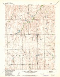 1961 Kirwin SE1962 Print · USGSThe rural crossroads of Rooks, Phillips, Smith, and Osborne counties are captured here in the early sixties. Genealogists can locate family sites and rural landmarks like Bohemian Cem, Spring Branch Cem, and Ash Rock Sch 2.
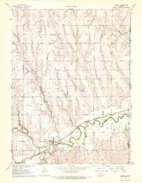
 - 1961 Map of Kirwin SW, 1963 Print
 1961 Kirwin SW1963 Print · USGSPhillips and Rooks County lands are captured here in the early sixties as the reservoir system reshaped the valley. Genealogists can locate family landmarks like the Greenwood Cem, Delmar Community Hall, and the West Hope Sch.
 - 1967 Map of Almena, 1969 Print
 1967 Almena1969 Print · USGSNorthwestern Kansas in the late sixties reveals a landscape shaped by the paths of Prairie Dog Creek and two major regional railroads. Researchers can trace family history at several rural sites like Mt Hope Cem or Farmingdale Cem and follow the routes of the C B & Q and Chicago Rock Island and Pacific.
 - 1967 Map of Long Island, 1969 Print
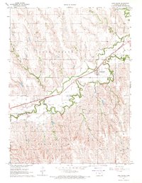 1967 Long Island1969 Print · USGSPhillips County in the late sixties shows a landscape shaped by the waters of Prairie Dog Creek and the steel of the Chicago Burlington and Quincy. Genealogists and historians can trace family roots at Vineman Cem or study the town center of Long Island.
 - 1968 Map of Woodruff, 1969 Print
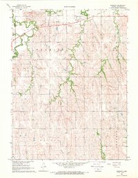 1968 Woodruff1969 Print · USGSWoodruff and the surrounding Phillips County plains are captured here in the late sixties as a landscape defined by its creek valleys and rail history. You can trace the Old Railroad Grade along Prairie Dog Creek and locate family sites at the Woodruff Cem or near the local Quarries.
End of results
Showing maps 1-5 of 5
Top cities of Phillips County
- Phillipsburg historical maps
- Logan historical maps
- Agra historical maps
- Kirwin historical maps
- Long Island historical maps
- Prairie View historical maps
See more
Frequently asked questions
- What are the different types of historical maps available for Phillips County?
- What is the oldest map of Phillips County?
- Where can I purchase historical maps of Phillips County for my home or office?
- Where can I download high-res historical maps of Phillips County?
- Are there historical topographic maps available for Phillips County?
- Is there historical aerial imagery available for Phillips County?
- Where are historical maps of Phillips County sourced from?