1980s Maps of Rawlins County, Kansas
Explore 9 historic maps of Rawlins County from the 1980s. These maps offer a rare glimpse into what life looked like during the 1980s — showing old roads, neighborhoods, homes, and landmarks that have changed or disappeared over time.
Whether you're researching your family's past, planning a metal detecting trip, or studying how Rawlins County's landscape evolved across the 1980s, these high-resolution maps are a powerful tool for exploring the history of this region.
- Focus on a specific era: All maps on this page are from the 1980s, giving you a focused view of this time period.
- See what’s changed: Compare century-old streets, trails, and buildings to today's modern landscape using overlays and satellite layers.
- Research with precision: Use these maps for genealogy, historical research, land use analysis, or educational projects.
- View, download, or print: Maps are fully viewable online in high resolution, and can be downloaded or printed for your own records.
Start exploring Rawlins County's history through authentic maps from the 1980s. This is your window into the past.
Rawlins County, KS maps
(9)- 1981 Map of Dewey Ranch SW
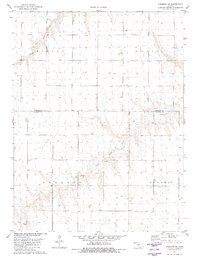
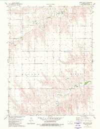
 1981 Dewey Ranch SW1981 Print · USGSThe high plains of Northwest Kansas are captured here in the early 1980s, where the corners of four different counties meet. Genealogists and historians can locate remote landmarks like Fairview Cem, Central Ch, and the workings of the Llanos Oil Field.
 - 1981 Map of Chardon NW
 1981 Chardon NW1981 Print · USGSThe High Plains of Rawlins County are captured here in the late seventies, showing a land of organized townships and winding creek beds. Researchers can trace rural landmarks like Stevens Chapel and the courses of Beaver Creek and North Fork Sappa Creek.
 - 1981 Map of Chardon SE
 1981 Chardon SE1981 Print · USGSHigh plains agriculture and the drainage of Middle Fork Sappa Creek define this Northwest Kansas landscape in the early eighties. Researchers can trace land use patterns across Grant and Clinton townships, locating remote Well sites and Gravel Pits.
 - 1981 Map of Chardon SW
 1981 Chardon SW1981 Print · USGSNorthwestern Kansas in the late 1970s is shown here as a landscape of structured townships and creek drainages. Researchers can locate the Ilion Cem or trace the winding courses of the Middle Fork Sappa Creek and North Fork Sappa Creek.
 - 1981 Map of Dewey Ranch
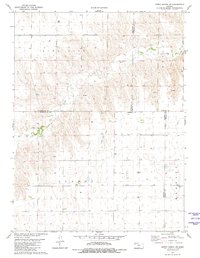
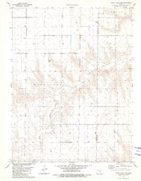
 1981 Dewey Ranch1981 Print · USGSRawlins County ranching country is mapped here in the early eighties, showing the drainage of the Beaver Creeks. Local researchers can locate Dewey Ranch and trace resource markers like the Quarry and various wells across the Mirage and Celia townships.
 - 1981 Map of Dewey Ranch NW
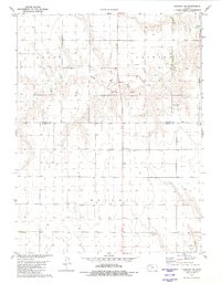
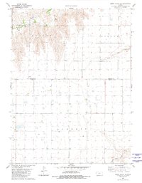
 1981 Dewey Ranch NW1981 Print · USGSHigh plains topography and county line divisions define this northwest Kansas landscape during the early 1980s. Researchers can trace the drainage of Little Beaver Creek and locate early resource sites including a Quarry and numerous Well locations.
 - 1981 Map of Dewey Ranch SE
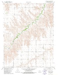
 1981 Dewey Ranch SE1981 Print · USGSThomas County and the surrounding plains are captured in the early eighties as a network of High Plains drainage and rural homesteads. Genealogists and researchers can trace land divisions across Mirage and Barrett, or locate early water sources like Beaver Creek and several rural wells.
 - 1985 Map of St. Francis
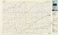
 1985 St. Francis1985 Print · USGSNorthwest Kansas in the mid-1980s shows a classic High Plains settlement pattern anchored by the Burlington Northern rail line. Genealogists and researchers can trace local landmarks from St Francis to Atwood, including rural aviation sites like Bird City's landing field and the St Francis State Wildlife Management Area.2 unique versions available
 - 1985 Map of Oberlin
 1985 Oberlin1985 Print · USGSNorthwest Kansas in the mid-eighties was a landscape of resilient prairie towns and winding creek drainages. Researchers can trace the Burlington Northern rail corridor through Jennings and Selden or locate local landmarks like the Municipal Airport and Keith Sebelius Lake.2 unique versions available
End of results
Showing maps 1-9 of 9
Top cities of Rawlins County
- Atwood historical maps
- McDonald historical maps
- Herndon historical maps
- Ludell historical maps
- Achilles historical maps
Frequently asked questions
- What are the different types of historical maps available for Rawlins County?
- What is the oldest map of Rawlins County?
- Where can I purchase historical maps of Rawlins County for my home or office?
- Where can I download high-res historical maps of Rawlins County?
- Are there historical topographic maps available for Rawlins County?
- Is there historical aerial imagery available for Rawlins County?
- Where are historical maps of Rawlins County sourced from?