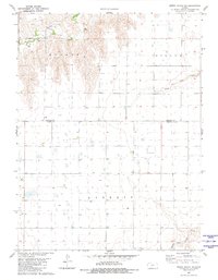
1981 Map of Dewey Ranch SE
USGS Topo · Published 1981About this map
Beaver Creek flows across the northern landscape of this High Plains region, carving a distinct valley through the townships of Mirage and Rotate. This early 1980s survey captures a rural landscape dominated by large-scale agricultural divisions and essential water resources, evidenced by the numerous wells scattered across the prairie. The topography is defined by the drainage systems of the North Fork Sappa Creek and Middle Fork Sappa Creek, which transition into the flatter reaches of Barrett. Small-scale industrial activity is limited to a single Gravel Pit near the northern boundary, while the border between Rawlins and Thomas County marks the primary political division. The map serves as a detailed record of water management and land usage in a period when small farm infrastructure remained critical to the regional economy.
Find a feature on this map
9 named features on this map. Tap any name to fly to it.
Don’t see what you’re looking for? This feature index may not catch every label — zoom into the map to look around manually.
Map Details
Editions of this 1981 Dewey Ranch SE Map
This is the sole edition of this map. No revisions or reprints were ever made.
Other maps of this area

1943 · Colby
USGS Topo · 1:62,500

1951 · Chardon
USGS Topo · 1:62,500

1951 · Dewey Ranch
USGS Topo · 1:62,500

1954 · Goodland
USGS Topo · 1:250,000

1956 · Goodland
USGS Topo · 1:250,000

1957 · Goodland
USGS Topo · 1:250,000

1966 · Brewster NW
USGS Topo · 1:24,000

1967 · Brewster NE
USGS Topo · 1:24,000

1967 · Levant
USGS Topo · 1:24,000
1981 · Dewey Ranch SW
USGS Topo · 1:24,000