1940s Maps of Riley County, Kansas
Explore 2 historic maps of Riley County from the 1940s. These maps offer a rare glimpse into what life looked like during the 1940s — showing old roads, neighborhoods, homes, and landmarks that have changed or disappeared over time.
Whether you're researching your family's past, planning a metal detecting trip, or studying how Riley County's landscape evolved across the 1940s, these high-resolution maps are a powerful tool for exploring the history of this region.
- Focus on a specific era: All maps on this page are from the 1940s, giving you a focused view of this time period.
- See what’s changed: Compare century-old streets, trails, and buildings to today's modern landscape using overlays and satellite layers.
- Research with precision: Use these maps for genealogy, historical research, land use analysis, or educational projects.
- View, download, or print: Maps are fully viewable online in high resolution, and can be downloaded or printed for your own records.
Start exploring Riley County's history through authentic maps from the 1940s. This is your window into the past.
Riley County, KS maps
(2)- 1947 Map of Manhattan, 1954 Print
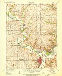
 1947 Manhattan1954 Print · USGSManhattan and the surrounding Kansas river valleys are shown here in the years immediately following World War II. Researchers can trace the extensive military works at Camp Funston, local education at College Hill Sch, and pioneer-era sites like St Patricks Cem.2 unique versions available
 - 1947 Map of Fort Riley, 1954 Print
 1947 Fort Riley1954 Print · USGSPost-war Kansas comes to life where the Smoky Hill and Republican rivers meet to form the Kansas River. Genealogists and historians can trace the foundations of Fort Riley, early settlements like Milford, and dozens of rural schools including Walla Walla Sch and Acme Sch.2 unique versions available
End of results
Showing maps 1-2 of 2
Top cities of Riley County
- Manhattan historical maps
- Ogden historical maps
- Riley historical maps
- Bala historical maps
- Leonardville historical maps
- Zeandale historical maps
See more
Frequently asked questions
- What are the different types of historical maps available for Riley County?
- What is the oldest map of Riley County?
- Where can I purchase historical maps of Riley County for my home or office?
- Where can I download high-res historical maps of Riley County?
- Are there historical topographic maps available for Riley County?
- Is there historical aerial imagery available for Riley County?
- Where are historical maps of Riley County sourced from?