1960s Maps of Riley County, Kansas
Explore 11 historic maps of Riley County from the 1960s. These maps offer a rare glimpse into what life looked like during the 1960s — showing old roads, neighborhoods, homes, and landmarks that have changed or disappeared over time.
Whether you're researching your family's past, planning a metal detecting trip, or studying how Riley County's landscape evolved across the 1960s, these high-resolution maps are a powerful tool for exploring the history of this region.
- Focus on a specific era: All maps on this page are from the 1960s, giving you a focused view of this time period.
- See what’s changed: Compare century-old streets, trails, and buildings to today's modern landscape using overlays and satellite layers.
- Research with precision: Use these maps for genealogy, historical research, land use analysis, or educational projects.
- View, download, or print: Maps are fully viewable online in high resolution, and can be downloaded or printed for your own records.
Start exploring Riley County's history through authentic maps from the 1960s. This is your window into the past.
Riley County, KS maps
(11)- 1963 Map of Bala, 1964 Print
 1963 Bala1964 Print · USGSThe rural border of Riley and Clay counties is captured in the early sixties, just as the landscape prepared for major inundation. Genealogists and local historians can trace family roots at Bala Cem, the Bethany Ch, or the site of Grange Hall.2 unique versions available
 - 1963 Map of Lasita, 1965 Print
 1963 Lasita1965 Print · USGSThe rural landscape along the Clay and Riley County line is captured here in the early sixties, showing the agricultural heartland before modern consolidation. Genealogists can locate family landmarks like Ebenezer Cem, May Day Cem, and the path of the Old Railroad Grade.2 unique versions available
 - 1964 Map of Tuttle Creek Dam, 1965 Print
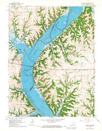
 1964 Tuttle Creek Dam1965 Print · USGSThe Big Blue River valley was recently transformed into a massive reservoir during the mid-sixties. Genealogists and researchers can locate family landmarks like Carnahan-Garrison Cem and Hayes Cem alongside the newly formed Tuttle Creek Reservoir.2 unique versions available
 - 1964 Map of Riley, 1965 Print
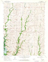
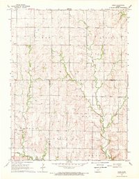
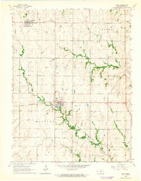 1964 Riley1965 Print · USGSRiley County in the mid-1960s showcases a landscape defined by steady agricultural townships and the steel of the Chicago Rock Island and Pacific. Researchers can trace the roots of local families at Riley Cem or find landmarks like the County High Sch and Fairview Ch.2 unique versions available
 - 1964 Map of Randolph, 1965 Print
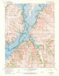
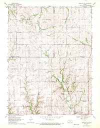
 1964 Randolph1965 Print · USGSThe Riley County landscape was undergoing a major transformation in the mid-sixties as the rising waters of Tuttle Creek Reservoir reshaped the valley. Local historians can trace old community landmarks like Walsburg, the Blue Valley High Sch, and Crooked Creek Cem.2 unique versions available
 - 1964 Map of Olsburg NW, 1965 Print
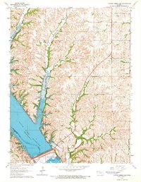
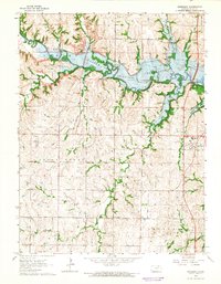
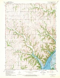
 1964 Olsburg NW1965 Print · USGSThe mid-century transformation of the Kansas river valleys is captured here as the newly created Tuttle Creek Reservoir fills the landscape. Researchers can trace the submerged course of the Big Blue River and locate several quarries and recreation spots like Fancy Creek State Park.3 unique versions available
 - 1964 Map of Olsburg SW, 1965 Print
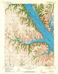 1964 Olsburg SW1965 Print · USGSThe Big Blue River valley near Manhattan was undergoing a major transformation in the early sixties as the new reservoir reshaped the Riley County landscape. Local history hunters can locate family landmarks like Sedalia, Hebron Cem, and the Carnahan-Garrison Cem before they were altered by development.3 unique versions available
 - 1968 Map of Blue Rapids SE, 1969 Print
 1968 Blue Rapids SE1969 Print · USGSMarshall County's river valleys underwent a massive shift in the late sixties as the reservoir waters reshaped the terrain. Genealogists and historians can locate the Proctor Cem, trace the Old Railroad Grade, and identify land within the Swede Creek and Blue Valley townships.2 unique versions available
 - 1968 Map of Kimeo, 1969 Print
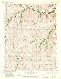
 1968 Kimeo1969 Print · USGSNortheastern Kansas was a patchwork of small townships and creek drainages in the late 1960s. Genealogists and historians can trace community roots through the Appleton Cem and rural centers like St Peter Ch or the local Townhall.2 unique versions available
 - 1968 Map of Greenleaf SE, 1970 Print
 1968 Greenleaf SE1970 Print · USGSRiley County and its neighboring borderlands appear here in the late sixties, showing a landscape of traditional farmsteads and creek-fed valleys. Genealogists can locate several historic burial sites, including Cottage Hill Cem, Peach Grove Cem, and the Peach Grove Ch.2 unique versions available
 - 1968 Map of Blue Rapids SW, 1970 Print
 1968 Blue Rapids SW1970 Print · USGSThe Big Blue River valley in the late sixties reveals a landscape transformed by the Tuttle Creek Reservoir and the rural heritage of Marshall and Riley counties. Genealogists can trace family footprints at Czech Cem, Swede Creek Ch, and Cottage Hill.2 unique versions available
End of results
Showing maps 1-11 of 11
Top cities of Riley County
- Manhattan historical maps
- Ogden historical maps
- Riley historical maps
- Bala historical maps
- Leonardville historical maps
- Zeandale historical maps
See more
Frequently asked questions
- What are the different types of historical maps available for Riley County?
- What is the oldest map of Riley County?
- Where can I purchase historical maps of Riley County for my home or office?
- Where can I download high-res historical maps of Riley County?
- Are there historical topographic maps available for Riley County?
- Is there historical aerial imagery available for Riley County?
- Where are historical maps of Riley County sourced from?