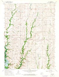
1963 Map of Bala
USGS Topo · Published 1964About this map
The Bala settlement and surrounding agricultural townships of Highland, Bala, Grant, and Madison define this rural landscape on the border of Clay Co and Riley Co. This early 1960s survey documents a critical period of geographic change as the southwestern corner prepared for the creation of the Milford Reservoir, with blue hatching indicating areas slated for submergence or controlled inundation. Local community life is rooted at Grange Hall and Bethany Ch, while the Bala Cem serves as a vital record for family historians. The Chicago Rock Island and Pacific railroad bisects the terrain, supporting a local economy that included an Oil Well and a stone Quarry. Meandering waterways like Mall Creek, Timber Creek, and Dry Creek continue to shape the drainage of these Kansas uplands before they reach the Republican River basin.
Find a feature on this map
16 named features on this map. Tap any name to fly to it.
Don’t see what you’re looking for? This feature index may not catch every label — zoom into the map to look around manually.
Map Details
Editions of this 1963 Bala Map
2 editions found
Other maps of this area

1886 · Junction City
USGS Topo · 1:125,000

1889 · Junction City
USGS Topo · 1:125,000

1891 · Clay Center
USGS Topo · 1:125,000

1894 · Junction City
USGS Topo · 1:125,000

1947 · Fort Riley
USGS Topo · 1:62,500

1951 · Wind Creek
USGS Topo · 1:24,000

1951 · Milford
USGS Topo · 1:24,000

1955 · Fort Riley NE
USGS Topo · 1:24,000

1955 · Milford
USGS Topo · 1:24,000

1955 · Manhattan
USGS Topo · 1:250,000