1800s (19th Century) Maps of Rooks County, Kansas
Explore 4 historic maps of Rooks County from the 1800s (19th Century). These maps offer a rare glimpse into what life looked like during the 1800s — showing old roads, neighborhoods, homes, and landmarks that have changed or disappeared over time.
Whether you're researching your family's past, planning a metal detecting trip, or studying how Rooks County's landscape evolved across the 1800s, these high-resolution maps are a powerful tool for exploring the history of this region.
- Focus on a specific era: All maps on this page are from the 1800s, giving you a focused view of this time period.
- See what’s changed: Compare century-old streets, trails, and buildings to today's modern landscape using overlays and satellite layers.
- Research with precision: Use these maps for genealogy, historical research, land use analysis, or educational projects.
- View, download, or print: Maps are fully viewable online in high resolution, and can be downloaded or printed for your own records.
Start exploring Rooks County's history through authentic maps from the 1800s. This is your window into the past.
Rooks County, KS maps
(4)- 1893 Map of Norton
 1893 Norton1893 Print · USGSNorthwest Kansas during the mid-1890s shows a region defined by the growth of railroad towns and water-carved valleys. Genealogists and historians can trace early town sites and rail lines including Norton, Almena, and the Pacific Railroad route through Logan.4 unique versions available
 - 1893 Map of Phillipsburg
 1893 Phillipsburg1893 Print · USGSPhillips County was a burgeoning rail and river corridor in the 1890s, with three major railroads carving paths through the prairie townships. Genealogists and researchers can trace the early layouts of Phillipsburg, Kirwin, and Agra as they appeared before the turn of the century.4 unique versions available
 - 1893 Map of Hill
 1893 Hill1893 Print · USGSNorthwestern Kansas in the early 1890s shows a landscape of developing prairie townships and the vital Union Pacific Railway corridor. Researchers can trace the early footprint of the historic colony at Nicodemus and find old stations like Millbrook and Paleo.4 unique versions available
 - 1896 Map of Plainville
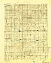
 1896 Plainville1896 Print · USGSThe Rooks County high plains are seen here in the 1890s as the rail networks expanded across the Solomon and Saline river valleys. Genealogists can trace family roots in early settlements like Plainville, Stockton, and the vanished site of Turkville.3 unique versions available
End of results
Showing maps 1-4 of 4
Top cities of Rooks County
- Plainville historical maps
- Stockton historical maps
- Palco historical maps
- Damar historical maps
- Zurich historical maps
- Woodston historical maps
Frequently asked questions
- What are the different types of historical maps available for Rooks County?
- What is the oldest map of Rooks County?
- Where can I purchase historical maps of Rooks County for my home or office?
- Where can I download high-res historical maps of Rooks County?
- Are there historical topographic maps available for Rooks County?
- Is there historical aerial imagery available for Rooks County?
- Where are historical maps of Rooks County sourced from?