1950s Maps of Rooks County, Kansas
Explore 6 historic maps of Rooks County from the 1950s. These maps offer a rare glimpse into what life looked like during the 1950s — showing old roads, neighborhoods, homes, and landmarks that have changed or disappeared over time.
Whether you're researching your family's past, planning a metal detecting trip, or studying how Rooks County's landscape evolved across the 1950s, these high-resolution maps are a powerful tool for exploring the history of this region.
- Focus on a specific era: All maps on this page are from the 1950s, giving you a focused view of this time period.
- See what’s changed: Compare century-old streets, trails, and buildings to today's modern landscape using overlays and satellite layers.
- Research with precision: Use these maps for genealogy, historical research, land use analysis, or educational projects.
- View, download, or print: Maps are fully viewable online in high resolution, and can be downloaded or printed for your own records.
Start exploring Rooks County's history through authentic maps from the 1950s. This is your window into the past.
Rooks County, KS maps
(6)- 1952 Map of Webster Dam, 1955 Print
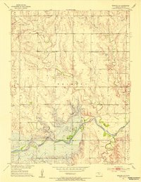 1952 Webster Dam1955 Print · USGSRooks County was on the brink of a major transformation in the early 1950s as the Missouri River Basin project began reshaping the Solomon valley. Researchers can trace the original townsite of Webster and nearby landmarks like Mt Vernon Cem before they were impacted by the Webster Dam.2 unique versions available
 - 1953 Map of Woodston NW, 1954 Print
 1953 Woodston NW1954 Print · USGSRooks County agriculture and transport are centered along the river valley in the early fifties. Genealogists and local historians can trace the foundations of the community through the Woodston Cem, New Hope Sch, and the Missouri Pacific rail line.2 unique versions available
 - 1953 Map of Stockton, 1954 Print
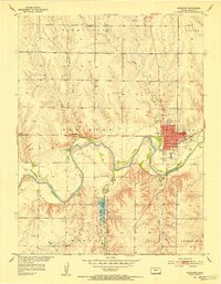 1953 Stockton1954 Print · USGSStockton and the Rooks County plains are captured here in the early fifties, following the course of the South Fork Solomon River. Genealogists can locate rural landmarks like Mt Nebo Sch, the Old Stockton Cem, and the Community Hall.3 unique versions available
 - 1953 Map of Woodston, 1954 Print
 1953 Woodston1954 Print · USGSThe town of Woodston and its surrounding townships are shown here in the early fifties, caught between the river and the rail line. Researchers can trace the mid-century footprint of local education and community at High Sch, Pleasant Valley Sch, and the Pleasant Valley Cem.2 unique versions available
 - 1955 Map of Beloit, 1971 Print
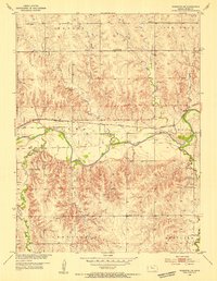
 1955 Beloit1971 Print · USGSNorth Central Kansas in the mid-fifties shows a landscape of river-valley agriculture and expanding water infrastructure. Genealogists can trace the rail lines of the Union Pacific through towns like Nicodemus, Cawker City, and the State Sanatorium.3 unique versions available
 - 1959 Map of Beloit
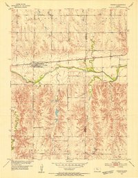
 1959 Beloit1959 Print · USGSNorth Central Kansas at mid-century reveals a landscape shaped by river valleys and the expansion of massive water reservoirs. Genealogists and historians can trace the rail-town connections of Beloit and Norton or locate the site of the new Webster Dam.3 unique versions available
End of results
Showing maps 1-6 of 6
Top cities of Rooks County
- Plainville historical maps
- Stockton historical maps
- Palco historical maps
- Damar historical maps
- Zurich historical maps
- Woodston historical maps
Frequently asked questions
- What are the different types of historical maps available for Rooks County?
- What is the oldest map of Rooks County?
- Where can I purchase historical maps of Rooks County for my home or office?
- Where can I download high-res historical maps of Rooks County?
- Are there historical topographic maps available for Rooks County?
- Is there historical aerial imagery available for Rooks County?
- Where are historical maps of Rooks County sourced from?