
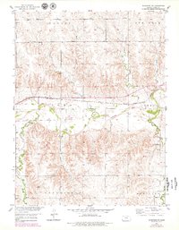
1953 Map of Woodston NW
USGS Topo · Published 1954About this map
The South Fork Solomon River cuts a prominent path across this landscape in Rooks County, following a corridor shared with the Missouri Pacific railroad. This alignment reflects the typical mid-century rural Kansas economy, where river valleys dictated the placement of rail infrastructure to move agricultural products. The surrounding upland townships, including Lanark, Ash Rock, and Greenfield, are dotted with essential community hubs like the New Hope Sch and Sunny Slope Sch, illustrating the dispersed nature of rural education before widespread school consolidation. Near the river's bend, the Woodston Cem serves as a genealogical anchor for the area, while smaller local industries are noted by a Gravel Pit and various creek systems such as Medicine Creek and Douglas Creek that drain the undulating terrain into the central valley.
Find a feature on this map
17 named features on this map. Tap any name to fly to it.
Don’t see what you’re looking for? This feature index may not catch every label — zoom into the map to look around manually.
Map Details
Editions of this 1953 Woodston NW Map
2 editions found
Other maps of this area

1893 · Phillipsburg
USGS Topo · 1:125,000

1896 · Plainville
USGS Topo · 1:125,000

1953 · Stockton
USGS Topo · 1:24,000

1953 · Woodston
USGS Topo · 1:24,000

1955 · Beloit
USGS Topo · 1:250,000

1959 · Beloit
USGS Topo · 1:250,000

1961 · Kirwin SE
USGS Topo · 1:24,000

1961 · Kirwin SW
USGS Topo · 1:24,000
1972 · Glade SE
USGS Topo · 1:24,000
1978 · Twin Mound
USGS Topo · 1:24,000