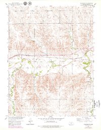
1953 Map of Woodston NW
USGS Topo · Published 1979About this map
The South Fork Solomon River defines the central valley of this Rooks County landscape, where the Missouri Pacific railroad corridor tracks the northern bank of the water. This 1950s survey, updated with late-1970s revisions, illustrates a rural economy transitioning between traditional agriculture and resource extraction. While the valley floor is dominated by river bends and the Woodston Cem, the surrounding uplands like Lanark and Ash Rock are etched with numerous drainages including East Branch Jim Creek and Douglas Creek. Evidence of industrial activity is scattered throughout the township divisions, ranging from a Quarry and Gravel Pit near the rail line to several Oil Wells located further south in Greenfield. These features, alongside family-named landmarks like Buros Creek, offer a detailed view of the land use patterns in north-central Kansas during the mid-twentieth century.
Find a feature on this map
24 named features on this map. Tap any name to fly to it.
Don’t see what you’re looking for? This feature index may not catch every label — zoom into the map to look around manually.
Map Details
Editions of this 1953 Woodston NW Map
2 editions found
Other maps of this area

1893 · Phillipsburg
USGS Topo · 1:125,000

1896 · Plainville
USGS Topo · 1:125,000

1953 · Woodston NW
USGS Topo · 1:24,000

1953 · Stockton
USGS Topo · 1:24,000

1953 · Woodston
USGS Topo · 1:24,000

1955 · Beloit
USGS Topo · 1:250,000

1959 · Beloit
USGS Topo · 1:250,000

1961 · Kirwin SE
USGS Topo · 1:24,000

1961 · Kirwin SW
USGS Topo · 1:24,000
1972 · Glade SE
USGS Topo · 1:24,000