1970s Maps of Rooks County, Kansas
Explore 11 historic maps of Rooks County from the 1970s. These maps offer a rare glimpse into what life looked like during the 1970s — showing old roads, neighborhoods, homes, and landmarks that have changed or disappeared over time.
Whether you're researching your family's past, planning a metal detecting trip, or studying how Rooks County's landscape evolved across the 1970s, these high-resolution maps are a powerful tool for exploring the history of this region.
- Focus on a specific era: All maps on this page are from the 1970s, giving you a focused view of this time period.
- See what’s changed: Compare century-old streets, trails, and buildings to today's modern landscape using overlays and satellite layers.
- Research with precision: Use these maps for genealogy, historical research, land use analysis, or educational projects.
- View, download, or print: Maps are fully viewable online in high resolution, and can be downloaded or printed for your own records.
Start exploring Rooks County's history through authentic maps from the 1970s. This is your window into the past.
Rooks County, KS maps
(11)- 1972 Map of Glade SW, 1974 Print
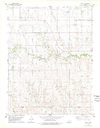
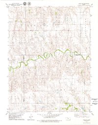
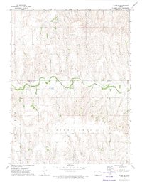 1972 Glade SW1974 Print · USGSThe Kansas borderlands of Phillips and Rooks counties come alive in the early seventies, centered on the winding Bow Creek. Researchers can trace local heritage through the Plainview Cem, Mt Pleasant Ch, and various township Townhall sites.
 - 1972 Map of Glade SE, 1974 Print
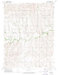 1972 Glade SE1974 Print · USGSThe borderlands of Phillips and Rooks counties come into focus in the early 1970s, showcasing a landscape of section-line roads and prairie creek beds. Genealogists and local historians can pinpoint the Lockwood Cem, the local Townhall, and the winding course of Bow Creek.
 - 1978 Map of Natoma, 1979 Print
 1978 Natoma1979 Print · USGSThe Kansas plains of the late seventies come alive on this sheet centered on the rail-side community of Natoma. Researchers can trace the legacy of local industry and genealogy through the Oil Field and landmarks like Conger Cem.
 - 1978 Map of Plainville, 1979 Print
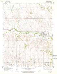
 1978 Plainville1979 Print · USGSIn the late seventies, this Rooks County landscape centered on the intersection of prairie agriculture and the booming energy industry. Trace the town's layout through landmarks like the Drive-in Theater, the Union Pacific rail line, and Plainville Twp Lake.
 - 1978 Map of Codell, 1979 Print
 1978 Codell1979 Print · USGSRooks and Ellis counties in the late 1970s reveal a landscape shaped by petroleum and rail. Researchers can trace the Union Pacific corridor through Codell and locate family burial sites at Shiloh Cem and Center Cem.
 - 1978 Map of Twin Mound, 1979 Print
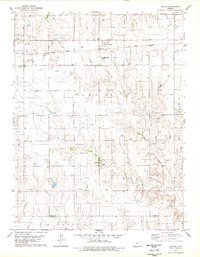
 1978 Twin Mound1979 Print · USGSRooks County in the late seventies reveals a landscape where ranching roots meet the machinery of the energy industry. Researchers can find old burial sites like Twin Mound Cem and Johnson Cem alongside an extensive Oil Field.
 - 1978 Map of Zurich, 1979 Print
 1978 Zurich1979 Print · USGSZurich thrived as a hub for both rail transit and petroleum extraction in the late seventies. Family historians and researchers can trace the Union Pacific line, locate the community Cem, and map the extensive Oil Field and numerous Oil Wells across the county line.
 - 1978 Map of Laton, 1979 Print
 1978 Laton1979 Print · USGSRooks and Osborne Counties appear here in the late 1970s, showcasing the rural character of the Kansas prairie. Genealogists and historians can trace family roots through several landmarks, including Laton, the Pleasant Plain Church, and Chalk Mound Cemetery.
 - 1978 Map of Stockton SE, 1979 Print
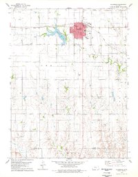
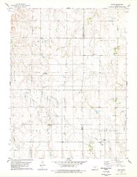
 1978 Stockton SE1979 Print · USGSRooks County in the late seventies is captured here at a height of rural energy production and local development. Genealogists and historians can trace the expansive Oil Field network, locate the Stockton Municipal Airport, or find early landmarks like the County Country Club.
 - 1979 Map of Logan SE
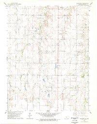
 1979 Logan SE1979 Print · USGSPhillips and Rooks Counties at the close of the 1970s show a structured agricultural landscape shaped by local watercourses and early industry. Family historians can trace rural roots near Prairie Dale Cem or the settlement of Towanda, while following Bow Creek across the county lines.
 - 1979 Map of Wild Horse Creek
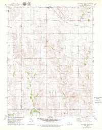 1979 Wild Horse Creek1979 Print · USGSIn the late 1970s, this Rooks County landscape was a hub of energy production and rail transport. Genealogists and historians can trace the community structures of Palco and find landmarks like Pleasantview Cem and the Marcotte Oil Field.2 unique versions available
End of results
Showing maps 1-11 of 11
Top cities of Rooks County
- Plainville historical maps
- Stockton historical maps
- Palco historical maps
- Damar historical maps
- Zurich historical maps
- Woodston historical maps
Frequently asked questions
- What are the different types of historical maps available for Rooks County?
- What is the oldest map of Rooks County?
- Where can I purchase historical maps of Rooks County for my home or office?
- Where can I download high-res historical maps of Rooks County?
- Are there historical topographic maps available for Rooks County?
- Is there historical aerial imagery available for Rooks County?
- Where are historical maps of Rooks County sourced from?