1960s Maps of Saline County, Kansas
Explore 10 historic maps of Saline County from the 1960s. These maps offer a rare glimpse into what life looked like during the 1960s — showing old roads, neighborhoods, homes, and landmarks that have changed or disappeared over time.
Whether you're researching your family's past, planning a metal detecting trip, or studying how Saline County's landscape evolved across the 1960s, these high-resolution maps are a powerful tool for exploring the history of this region.
- Focus on a specific era: All maps on this page are from the 1960s, giving you a focused view of this time period.
- See what’s changed: Compare century-old streets, trails, and buildings to today's modern landscape using overlays and satellite layers.
- Research with precision: Use these maps for genealogy, historical research, land use analysis, or educational projects.
- View, download, or print: Maps are fully viewable online in high resolution, and can be downloaded or printed for your own records.
Start exploring Saline County's history through authentic maps from the 1960s. This is your window into the past.
Saline County, KS maps
(10)- 1963 Map of Juniata, 1964 Print
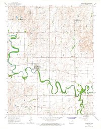
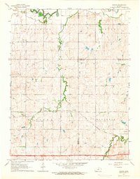 1963 Juniata1964 Print · USGSCentral Kansas at the start of the 1960s shows a landscape defined by the convergence of three counties and steady rail traffic. Genealogists and local historians can trace the paths of the Atchison Topeka and Santa Fe through Juniata and find the rural Monroe Cem.2 unique versions available
 - 1963 Map of Holland, 1965 Print
 1963 Holland1965 Print · USGSDickinson County farming communities are documented here in the early sixties, showing the rural townships of Lincoln and Garfield. Genealogists can locate Green Lawn Cem, while local historians can trace the sites of Acme and the Grace & Truth Gospel Chapel.
 - 1963 Map of Solomon, 1965 Print
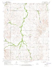
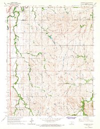
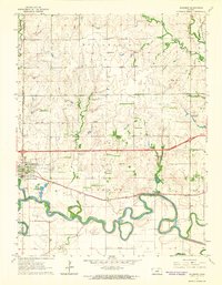 1963 Solomon1965 Print · USGSThe confluence of the Smoky Hill River and two major railroads defined life in central Kansas during the early sixties. Researchers can trace family landmarks like Willowdale Ch, Prairie Mound Cem, and the King Solomon Camp as the interstate era began.3 unique versions available
 - 1964 Map of Carlton, 1965 Print
 1964 Carlton1965 Print · USGSThe rural border of Dickinson and Saline counties is captured here in the mid-1960s, centered on the village of Carlton. Genealogists and local historians can trace the Missouri Pacific rail line and locate family burial sites at Fairview Cem and Woodlawn Cem.3 unique versions available
 - 1964 Map of Marquette, 1965 Print
 1964 Marquette1965 Print · USGSMarquette and the surrounding McPherson County plains appear here in the mid-1960s, defined by the winding Smoky Hill River. Researchers can trace the Missouri Pacific rail line and locate community landmarks like Freemount Ch and Mackie.2 unique versions available
 - 1964 Map of Gypsum SE, 1965 Print
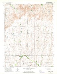 1964 Gypsum SE1965 Print · USGSThis central Kansas landscape at the dawn of the sixties shows a deep-rooted rural community where the North Cottonwood River winds through fertile plains. Genealogists can trace family footprints across numerous sites like Elm Springs, the Grand Central Sch, and Friedenstal Cem.3 unique versions available
 - 1964 Map of Langley, 1965 Print
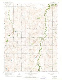
 1964 Langley1965 Print · USGSThe rural borderlands of Ellsworth and McPherson counties are captured here in the mid-1960s. Genealogists can trace family footprints around the village of Langley, the Langley Sch, and the riverside Sandpits along the Smoky Hill River.2 unique versions available
 - 1964 Map of Roxbury, 1966 Print
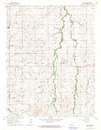
 1964 Roxbury1966 Print · USGSRoxbury and the surrounding townships in McPherson and Saline counties are shown here during a mid-century peak in local petroleum production. Genealogists and researchers can trace family lands near the Roxbury Oil Field or locate burial sites at Eureka Cem and Valley View Memorial Cem.3 unique versions available
 - 1965 Map of Lindsborg, 1966 Print
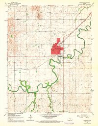 1965 Lindsborg1966 Print · USGSLindsborg and the surrounding Kansas prairie are documented here in the mid-sixties as the local economy shifted between agriculture and oil. Researchers can trace historic family plots at Smoky Hill Cem or locate defunct rural schoolhouses like Soderstrom Sch and Riverside Sch.3 unique versions available
 - 1965 Map of Lindsborg SE, 1966 Print
 1965 Lindsborg SE1966 Print · USGSMcPherson and Saline Counties are captured here in the mid-sixties, showing a landscape of traditional townships and rail corridors. Genealogists and historians can locate Smoky Hill Cem, the residential area of Alliance Acres, and the tracks of the Union Pacific Railroad.3 unique versions available
End of results
Showing maps 1-10 of 10
Top cities of Saline County
- Salina historical maps
- Assaria historical maps
- Gypsum historical maps
- Falun historical maps
- Brookville historical maps
- Smolan historical maps
See more
Frequently asked questions
- What are the different types of historical maps available for Saline County?
- What is the oldest map of Saline County?
- Where can I purchase historical maps of Saline County for my home or office?
- Where can I download high-res historical maps of Saline County?
- Are there historical topographic maps available for Saline County?
- Is there historical aerial imagery available for Saline County?
- Where are historical maps of Saline County sourced from?