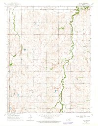
1963 Map of Holland
USGS Topo · Published 1965About this map
Holland Creek carves a winding path through this agricultural landscape in Dickinson County, illustrating the rural character of central Kansas in the early 1960s. The map reveals a network of small social and spiritual hubs, such as the Grace & Truth Gospel Chapel and Mt Pleasant Ch, which served the surrounding farming townships. While the settlement at Holland represents the primary named community, the presence of a Townhall and Community Hall indicates a structured civic life. Industrial activity is visible in the form of scattered Oil Wells and a Quarry, marking the extraction efforts that supplemented the regional economy. Family researchers will find value in the location of Green Lawn Cem and an additional Cem, providing specific touchpoints for local genealogy within the townships of Garfield and Wheatland.
Find a feature on this map
24 named features on this map. Tap any name to fly to it.
Don’t see what you’re looking for? This feature index may not catch every label — zoom into the map to look around manually.
Map Details
Editions of this 1963 Holland Map
This is the sole edition of this map. No revisions or reprints were ever made.
Other maps of this area

1889 · Abilene
USGS Topo · 1:125,000

1894 · Abilene
USGS Topo · 1:125,000

1955 · Niles
USGS Topo · 1:24,000

1955 · Kipp
USGS Topo · 1:24,000

1955 · Gypsum
USGS Topo · 1:24,000

1955 · Hutchinson
USGS Topo · 1:250,000

1959 · Hutchinson
USGS Topo · 1:250,000

1963 · Abilene SW
USGS Topo · 1:24,000
1963 · Solomon
USGS Topo · 1:24,000

1964 · Elmo
USGS Topo · 1:24,000