1800s (19th Century) Maps of Wichita, Kansas
Explore 7 historic maps of Wichita from the 1800s (19th Century). These maps offer a rare glimpse into what life looked like during the 1800s — showing old roads, neighborhoods, homes, and landmarks that have changed or disappeared over time.
Whether you're researching your family's past, planning a metal detecting trip, or studying how Wichita's landscape evolved across the 1800s, these high-resolution maps are a powerful tool for exploring the history of this region.
- Focus on a specific era: All maps on this page are from the 1800s, giving you a focused view of this time period.
- See what’s changed: Compare century-old streets, trails, and buildings to today's modern landscape using overlays and satellite layers.
- Research with precision: Use these maps for genealogy, historical research, land use analysis, or educational projects.
- View, download, or print: Maps are fully viewable online in high resolution, and can be downloaded or printed for your own records.
Start exploring Wichita's history through authentic maps from the 1800s. This is your window into the past.
Wichita, KS maps
(7)- 1889 Map of Cheney
 1889 Cheney1889 Print · USGSSouthern Kansas in the late nineteenth century was a landscape of emerging rail towns and river crossings. Genealogists and historians can trace early post offices like Waterloo P.O. and Ost P.O. alongside established hubs like Cheney and Mt. Hope.2 unique versions available
 - 1889 Map of Wichita
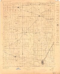
 1889 Wichita1889 Print · USGSWichita and its surrounding townships thrived as a rail-driven boomtown in the late nineteenth century. Genealogists can trace family footprints through early settlements like Oatville, Valley Center, and Douglass along the Arkansas River.
 - 1889 Map of Caldwell, 1957 Print
 1889 Caldwell1957 Print · USGSSouthern Kansas is captured in the late 1880s as the arrival of several major railroads began to spur the growth of new prairie towns. Researchers can locate early depots and homesteads in Caldwell, Conway Springs, and Runnymede.
 - 1891 Map of Cheney
 1891 Cheney1891 Print · USGSKansas prairie life in the 1890s centered on the arrival of the rails and the flow of the rivers. Genealogists and historians can trace early post offices like Stella P.O. and Mona P.O. or follow the path of the Wichita and Western Railroad through Cheney.2 unique versions available
 - 1893 Map of Caldwell
 1893 Caldwell1893 Print · USGSSouthern Kansas is captured during the rapid railroad expansion of the late nineteenth century, showing a landscape defined by new towns and steel rails. Genealogists can trace family roots through early settlements like Caldwell, Conway Springs, and Bluff City along the Chicaskia River.
 - 1894 Map of Wichita
 1894 Wichita1894 Print · USGSWichita and the surrounding prairie are captured here during the height of the Victorian era's railroad boom. Genealogists and historians can trace the early development of Wichita and find vanished stations and rural townships like Indianola, Oatville, and Green Station.5 unique versions available
 - 1897 Map of Caldwell
 1897 Caldwell1897 Print · USGSThe Kansas borderlands come alive in the late nineteenth century as a bustling network of railroads and prairie settlements. Genealogists and researchers can trace early homesteads and rail stops near Caldwell, Argonia, and the notable colonial experiment of Runnymede.10 unique versions available
End of results
Showing maps 1-7 of 7
Top cities near Wichita
- Derby historical maps
- Haysville historical maps
- Park City historical maps
- Bel Aire historical maps
- Mulvane historical maps
- Valley Center historical maps
See more
Top neighborhoods of Wichita
- The Dell historical maps
- Westlink Village historical maps
- Prospect historical maps
- Prospect Park historical maps
- Park East historical maps
- Midland historical maps
See more
Frequently asked questions
- What are the different types of historical maps available for Wichita?
- What is the oldest map of Wichita?
- Where can I purchase historical maps of Wichita for my home or office?
- Where can I download high-res historical maps of Wichita?
- Are there historical topographic maps available for Wichita?
- Is there historical aerial imagery available for Wichita?
- Where are historical maps of Wichita sourced from?