1980s Maps of Sumner County, Kansas
Explore 2 historic maps of Sumner County from the 1980s. These maps offer a rare glimpse into what life looked like during the 1980s — showing old roads, neighborhoods, homes, and landmarks that have changed or disappeared over time.
Whether you're researching your family's past, planning a metal detecting trip, or studying how Sumner County's landscape evolved across the 1980s, these high-resolution maps are a powerful tool for exploring the history of this region.
- Focus on a specific era: All maps on this page are from the 1980s, giving you a focused view of this time period.
- See what’s changed: Compare century-old streets, trails, and buildings to today's modern landscape using overlays and satellite layers.
- Research with precision: Use these maps for genealogy, historical research, land use analysis, or educational projects.
- View, download, or print: Maps are fully viewable online in high resolution, and can be downloaded or printed for your own records.
Start exploring Sumner County's history through authentic maps from the 1980s. This is your window into the past.
Sumner County, KS maps
(2)- 1985 Map of Ponca City
 1985 Ponca City1985 Print · USGSNorth-central Oklahoma during the mid-eighties shows a landscape shaped by petroleum and heavy rail. Trace the paths of the Atchison Topeka and Santa Fe through Ponca City or find local landmarks like Northern Oklahoma Junior College and Old Bliss.3 unique versions available
 - 1985 Map of Wellington
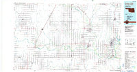
 1985 Wellington1985 Print · USGSSouthern Kansas in the mid-eighties reveals a landscape shaped by historical lines and rail commerce, from Wellington to the Arkansas River. Researchers can trace the Old Indian Treaty Boundary and locate family sites near Prairie Lawn Cem or Bluff City.2 unique versions available
End of results
Showing maps 1-2 of 2
Top cities of Sumner County
- Wellington historical maps
- Belle Plaine historical maps
- Conway Springs historical maps
- Caldwell historical maps
- Oxford historical maps
- Argonia historical maps
See more
Frequently asked questions
- What are the different types of historical maps available for Sumner County?
- What is the oldest map of Sumner County?
- Where can I purchase historical maps of Sumner County for my home or office?
- Where can I download high-res historical maps of Sumner County?
- Are there historical topographic maps available for Sumner County?
- Is there historical aerial imagery available for Sumner County?
- Where are historical maps of Sumner County sourced from?