1970s Maps of Sumner County, Kansas
Explore 12 historic maps of Sumner County from the 1970s. These maps offer a rare glimpse into what life looked like during the 1970s — showing old roads, neighborhoods, homes, and landmarks that have changed or disappeared over time.
Whether you're researching your family's past, planning a metal detecting trip, or studying how Sumner County's landscape evolved across the 1970s, these high-resolution maps are a powerful tool for exploring the history of this region.
- Focus on a specific era: All maps on this page are from the 1970s, giving you a focused view of this time period.
- See what’s changed: Compare century-old streets, trails, and buildings to today's modern landscape using overlays and satellite layers.
- Research with precision: Use these maps for genealogy, historical research, land use analysis, or educational projects.
- View, download, or print: Maps are fully viewable online in high resolution, and can be downloaded or printed for your own records.
Start exploring Sumner County's history through authentic maps from the 1970s. This is your window into the past.
Sumner County, KS maps
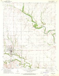
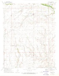
(12)- 1971 Map of Norwich, 1972 Print
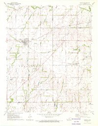 1971 Norwich1972 Print · USGSThe rural landscape around Norwich and Milton is shown here in the early 1970s, where two major rail lines intersect among the Kansas townships. Genealogists and historians can trace the Old Indian Treaty Boundary and locate family markers at Upchurch Cem or Stitch Cem.
 - 1971 Map of Caldwell NW, 1972 Print
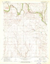 1971 Caldwell NW1972 Print · USGSSumner County’s river valley and petroleum fields are captured here in the early seventies as the energy industry transformed the rural landscape. Genealogists and local historians can trace family locations near Morris Center Cem or follow the Chikaskia River past the Yarnell Oil and Gas Field.
 - 1971 Map of Argonia, 1972 Print
 1971 Argonia1972 Print · USGSSumner and Harper Counties come together in the early 1970s at this bustling prairie rail junction. Researchers can trace the dual lines of the Atchison Topeka and Santa Fe and Missouri Pacific near Argonia and the Argonia Cem.
 - 1971 Map of Bluff City East, 1973 Print
 1971 Bluff City East1973 Print · USGSThe Kansas borderlands south of Bluff City come to life in this early 1970s survey of Harper and Sumner counties. Researchers can trace the Old Indian Treaty Boundary and locate family history at Pleasant Hill Cem or Devore Cem.
 - 1971 Map of Caldwell, 1973 Print
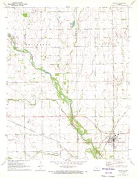
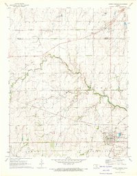
 1971 Caldwell1973 Print · USGSCaldwell and southern Sumner County are shown at a pivotal moment in the early seventies, centered on a major rail junction near the Oklahoma line. Genealogists and local historians can trace the Old Indian Treaty Boundary and locate family sites near Corzine Cem and Alton Cem.
 - 1971 Map of Millerton, 1973 Print
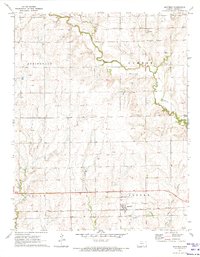
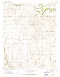 1971 Millerton1973 Print · USGSSumner County at the start of the 1970s reveals a prairie landscape shaped by historical borders and the oil industry. Genealogists and historians can trace the Old Indian Treaty Boundary or locate rural sites like Harrington Cem and Millerton.
 - 1971 Map of Perth, 1973 Print
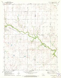
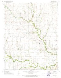
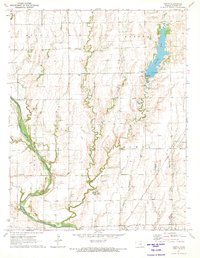 1971 Perth1973 Print · USGSSumner County during the early seventies reveals a landscape where the Chicago Rock Island and Pacific rail line still connects prairie towns like Perth and Corbin. Researchers can locate several burial grounds including United Cem and Bethany Cem or trace the drainage of the Chikaskia River.
 - 1971 Map of Milan, 1973 Print
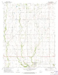 1971 Milan1973 Print · USGSSumner County during the early seventies reveals a landscape shaped by the Atchison Topeka and Santa Fe railroad and the Chikaskia River. Genealogists and local historians can locate the Amish Cem, Spring Hill Cem, and the grid of Milan.2 unique versions available
 - 1971 Map of Freeport, 1973 Print
 1971 Freeport1973 Print · USGSThe rural landscape of southern Kansas is captured here in the early seventies, centered on the small community of Freeport. Genealogists and local historians can trace the Missouri Pacific rail line and locate landmarks like H & S Cem or the Tracy Landing Field.
 - 1971 Map of Doster, 1973 Print
 1971 Doster1973 Print · USGSSumner County, Kansas, sits along the Oklahoma border in the early seventies, where the railroad and old survey lines still define the prairie. Genealogists can trace family names near Doster or visit the Cesko Slovensky Cem, while researchers can locate the Fall Creek Oil Field and the Old Indian Treaty Boundary.
 - 1971 Map of Mayfield, 1973 Print
 1971 Mayfield1973 Print · USGSSumner County in the early seventies shows a landscape of rail-connected farming towns and meandering prairie streams. Genealogists can locate family sites near Mayfield or Anson, and trace local burials at Austin Cem or Township Cem.
 - 1971 Map of Conway Springs, 1973 Print
 1971 Conway Springs1973 Print · USGSThe southern Kansas plains near the Sedgwick and Sumner county line are shown here in the early seventies, centered on the rail hub of Conway Springs. Researchers can trace the Old Indian Treaty Boundary and find family-history sites like St Josephs Cem and Anness.
End of results
Showing maps 1-12 of 12
Top cities of Sumner County
- Wellington historical maps
- Belle Plaine historical maps
- Conway Springs historical maps
- Caldwell historical maps
- Oxford historical maps
- Argonia historical maps
See more
Frequently asked questions
- What are the different types of historical maps available for Sumner County?
- What is the oldest map of Sumner County?
- Where can I purchase historical maps of Sumner County for my home or office?
- Where can I download high-res historical maps of Sumner County?
- Are there historical topographic maps available for Sumner County?
- Is there historical aerial imagery available for Sumner County?
- Where are historical maps of Sumner County sourced from?