1900s (20th Century) Maps of Sumner County, Kansas
Explore 36 historic maps of Sumner County from the 1900s (20th Century). These maps offer a rare glimpse into what life looked like during the 1900s — showing old roads, neighborhoods, homes, and landmarks that have changed or disappeared over time.
Whether you're researching your family's past, planning a metal detecting trip, or studying how Sumner County's landscape evolved across the 1900s, these high-resolution maps are a powerful tool for exploring the history of this region.
- Focus on a specific era: All maps on this page are from the 1900s, giving you a focused view of this time period.
- See what’s changed: Compare century-old streets, trails, and buildings to today's modern landscape using overlays and satellite layers.
- Research with precision: Use these maps for genealogy, historical research, land use analysis, or educational projects.
- View, download, or print: Maps are fully viewable online in high resolution, and can be downloaded or printed for your own records.
Start exploring Sumner County's history through authentic maps from the 1900s. This is your window into the past.
Sumner County, KS maps
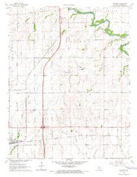
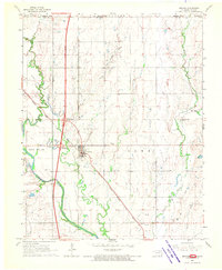
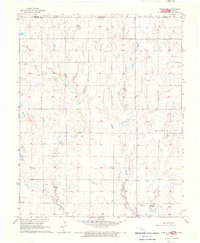
(36)- 1955 Map of Belle Plaine, 1956 Print
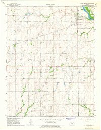
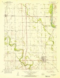 1955 Belle Plaine1956 Print · USGSSumner County in the mid-fifties is captured at a crossroads of tradition and modern transit as the new Kansas Turnpike spans the prairie. Researchers can locate vanished landmarks like New Salem Sch and Council Hill Ch or trace the Old Indian Boundary across the Arkansas River valley.2 unique versions available
 - 1955 Map of Zyba, 1956 Print
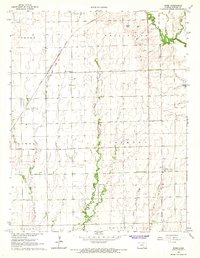
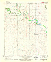
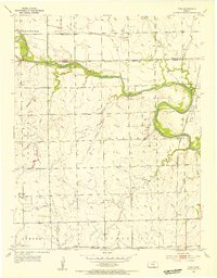 1955 Zyba1956 Print · USGSSumner County farmland and the winding Ninnescah River valley are captured here in the mid-fifties as the local oil industry began to shape the landscape. Researchers can trace the path of the Chicago Rock Island and Pacific railroad to the settlement of Zyba or locate family plots at Worden Cem and Porter Cem.2 unique versions available
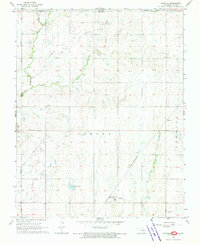
 - 1955 Map of Mulvane, 1956 Print
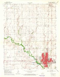
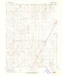
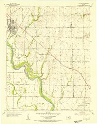 1955 Mulvane1956 Print · USGSThe rail-and-river landscape surrounding mid-century Mulvane is captured here at the intersection of four Kansas counties. Researchers can trace the original Atchison Topeka and Santa Fe corridor and locate local landmarks like Littleton Cem and Central Sch.
 - 1955 Map of Wichita, 1959 Print
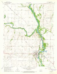
 1955 Wichita1959 Print · USGSSouth-central Kansas comes alive in the mid-1950s as Wichita grows into its role as a regional industrial and military powerhouse. Trace the rail-and-river network connecting El Dorado and Arkansas City through the Atchison Topeka and Santa Fe lines.3 unique versions available
 - 1955 Map of Enid, 1966 Print
 1955 Enid1966 Print · USGSNorth-central Oklahoma's transition from open plains to the blackjack hills of the Osage Indian Reservation is captured in the mid-1950s. Researchers can trace the development of the Naval Reserve Oil Field, the grounds of Vance AFB, and the early footprints of Tulsa and Stillwater.4 unique versions available
 - 1958 Map of Enid
 1958 Enid1958 Print · USGSNorthern Oklahoma is mapped here in the late fifties, showcasing a dense network of petroleum production and historic tribal lands. Researchers can trace the legacy of the Osage Indian Reservation, early energy hubs like the Cushing Oil Field, and the Chilocco Indian Agricultural School.2 unique versions available
 - 1958 Map of Wichita
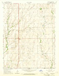
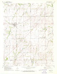
 1958 Wichita1958 Print · USGSSouth Central Kansas in the late fifties was a landscape of aviation industry, oil exploration, and expanding turnpikes. Researchers can trace mid-century growth through McConnell Air Force Base, major facilities for Cessna Aircraft Company, and the active El Dorado Oil Field.
 - 1964 Map of South Haven NE, 1966 Print
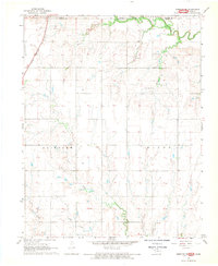
 1964 South Haven NE1966 Print · USGSSumner County in the mid-1960s shows a rural landscape adapting to the modern era as the new turnpike bisects traditional farmsteads. Genealogists and local historians can locate several country schoolhouses like Union Sch and Plainview Sch, or trace family sites near Jordan Cem.
 - 1964 Map of Dalton, 1966 Print
 1964 Dalton1966 Print · USGSSumner County in the mid-sixties shows a landscape defined by the intersection of the new Kansas Turnpike and historic rail lines. Genealogists can trace the rural legacy of Pink Sch and the development of the Interchange Oil Field near Dalton.
 - 1965 Map of Portland, 1966 Print
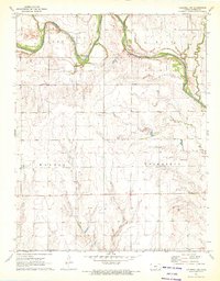
 1965 Portland1966 Print · USGSSumner County during the mid-1960s reveals a landscape defined by petroleum production and the legacy of the Indian Treaty Boundary. Researchers can trace the rail-and-road economy through the Portland settlement, the Kansas Turnpike, and the Forest Hill Cem.2 unique versions available
 - 1965 Map of Adamsville, 1966 Print
 1965 Adamsville1966 Print · USGSSumner and Cowley counties at the mid-point of the sixties show a landscape where the river bend economy meets the oil field. Genealogists and local researchers can locate Oak Grove Sch, Adamsville, and the Geuda Springs Cem along the winding Arkansas River.
 - 1965 Map of South Haven, 1966 Print
 1965 South Haven1966 Print · USGSThe Kansas-Oklahoma borderlands in the mid-1960s reveal a landscape of rail-dependent towns and historic territorial lines. Trace the Old Indian Treaty Boundary as it passes between the settlements of South Haven and Hunnewell.
 - 1965 Map of Geuda Springs, 1966 Print
 1965 Geuda Springs1966 Print · USGSSumner and Cowley counties come together along the Arkansas River in this mid-1960s survey of the Kansas prairie. Genealogists and historians can trace the Old Indian Treaty Boundary and locate family landmarks like Mt Hope Cem or Centerview Sch.
 - 1965 Map of Rome, 1966 Print
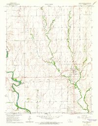
 1965 Rome1966 Print · USGSSumner County, Kansas, is captured here in the mid-1960s, showing a landscape defined by the intersection of major railroads and prairie waterways. Genealogists and historians can locate family landmarks like the Attebery Cem and the Dusty Corners Sch or trace the early footprint of the Perth Oil Field.
 - 1965 Map of Wellington, 1966 Print
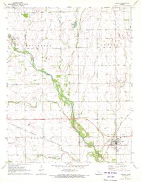
 1965 Wellington1966 Print · USGSWellington thrived in the mid-1960s as a major railroad crossroads and oil production center in Sumner County. Genealogists and researchers can trace local landmarks like Fairview Cem, several historic campus sites such as Slate Valley Sch, and the layout of the Anson Southeast Oil Field.2 unique versions available
 - 1965 Map of Oxford, 1966 Print
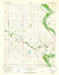
 1965 Oxford1966 Print · USGSThe river-and-rail hub of Oxford comes into sharp focus during the mid-1960s at the junction of the Arkansas River and Ninnescah River. Genealogists can locate family sites near Ninnescah Cem or trace industrial roots at the Slick-Carson Oil Field.2 unique versions available
 - 1967 Map of Braman, 1970 Print
 1967 Braman1970 Print · USGSBraman and its surrounding oil fields are captured in the late sixties at the intersection of traditional rail and new interstate travel. Genealogists and local historians can trace the Braman Cem, the rural settlement of Sumpter, and the course of the Chikaskia River.2 unique versions available
 - 1968 Map of Blackwell NW, 1970 Print
 1968 Blackwell NW1970 Print · USGSThe Oklahoma-Kansas borderlands are captured here in the late sixties, where the Chikaskia River winds through the northern prairie. Researchers can trace rural genealogy and industry through sites like Triumph Cem, the Asbury Ch, and the extensive Webb North Oil Field.2 unique versions available
 - 1968 Map of Renfrow, 1970 Print
 1968 Renfrow1970 Print · USGSNorthern Oklahoma prairie life in the late sixties centers on the rail corridor and expanding energy fields. Researchers can trace the Chicago Rock Island and Pacific line through Renfrow or locate the Richland Cem and early Gas Wells.
 - 1968 Map of Medford NE, 1970 Print
 1968 Medford NE1970 Print · USGSThe Kansas-Oklahoma border comes to life in the late sixties as the Chicago and Rock Island Pacific railroad connects local industry and agriculture. Researchers can trace rural community roots at North Star Ch or locate mid-century landmarks like the Drive-in Theater and Spring Creek Cem.2 unique versions available
 - 1968 Map of Wakita NE, 1970 Print
 1968 Wakita NE1970 Print · USGSThe Oklahoma-Kansas borderlands in the late sixties reveal a landscape of rural townships and active energy exploration. Genealogists and local historians can trace the Wakita Trend Gas Field and family sites near Springdale Cem or Pond Creek.
 - 1968 Map of Peckham, 1970 Print
 1968 Peckham1970 Print · USGSThe Kay County borderlands at the end of the sixties reveal a landscape shaped by petroleum and rail. Researchers can trace the Murphy Oil Field, locate the Church of God, and follow the St Louis - San Francisco line through Peckham.
 - 1971 Map of Norwich, 1972 Print
 1971 Norwich1972 Print · USGSThe rural landscape around Norwich and Milton is shown here in the early 1970s, where two major rail lines intersect among the Kansas townships. Genealogists and historians can trace the Old Indian Treaty Boundary and locate family markers at Upchurch Cem or Stitch Cem.
 - 1971 Map of Caldwell NW, 1972 Print
 1971 Caldwell NW1972 Print · USGSSumner County’s river valley and petroleum fields are captured here in the early seventies as the energy industry transformed the rural landscape. Genealogists and local historians can trace family locations near Morris Center Cem or follow the Chikaskia River past the Yarnell Oil and Gas Field.
 - 1971 Map of Argonia, 1972 Print
 1971 Argonia1972 Print · USGSSumner and Harper Counties come together in the early 1970s at this bustling prairie rail junction. Researchers can trace the dual lines of the Atchison Topeka and Santa Fe and Missouri Pacific near Argonia and the Argonia Cem.
Showing maps 1-25 of 36
Top cities of Sumner County
- Wellington historical maps
- Belle Plaine historical maps
- Conway Springs historical maps
- Caldwell historical maps
- Oxford historical maps
- Argonia historical maps
See more
Frequently asked questions
- What are the different types of historical maps available for Sumner County?
- What is the oldest map of Sumner County?
- Where can I purchase historical maps of Sumner County for my home or office?
- Where can I download high-res historical maps of Sumner County?
- Are there historical topographic maps available for Sumner County?
- Is there historical aerial imagery available for Sumner County?
- Where are historical maps of Sumner County sourced from?