
1955 Map of Belle Plaine
USGS Topo · Published 1956About this map
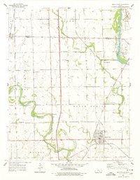
The Arkansas River and Ninnescah River converge in this mid-century landscape of south-central Kansas, where river meanders and floodplain levees define the local geography. The grid of the Kansas Turnpike cuts vertically through the township of Belle Plaine, juxtaposed against the older Old Indian Boundary that slices diagonally across the northern sections. This era shows a rural landscape still anchored by neighborhood institutions, with a high density of country schools including London Sch, Meekers Sch, and Meridian Sch serving the farming districts.
Find a feature on this map
31 named features on this map. Tap any name to fly to it.
Don’t see what you’re looking for? This feature index may not catch every label — zoom into the map to look around manually.
Map Details
Editions of this 1955 Belle Plaine Map
2 editions found
Other maps of this area

1889 · Wichita
USGS Topo · 1:125,000

1890 · Wellington
USGS Topo · 1:125,000

1894 · Wichita
USGS Topo · 1:125,000

1943 · Derby
USGS Topo · 1:31,680

1943 · Bayneville
USGS Topo · 1:31,680

1950 · Bayneville
USGS Topo · 1:24,000
1955 · Zyba
USGS Topo · 1:24,000

1955 · Rose Hill
USGS Topo · 1:24,000

1955 · Mulvane
USGS Topo · 1:24,000

1955 · Wichita
USGS Topo · 1:250,000