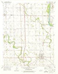
1955 Map of Belle Plaine
USGS Topo · Published 1978About this map
The Arkansas River and Ninnescah River converge in this mid-1950s survey of Sumner County, defining a fertile landscape dominated by transport and agriculture. The newly constructed Kansas Turnpike bisects the terrain, cutting a modern path through older rural divisions like the Old Indian Boundary. This era captures the transition of rural Kansas, where local schoolhouses such as New Salem Sch, Meekers Sch, and London Sch remained as vital community nodes alongside established spiritual centers like Council Hill Ch. In the town of Belle Plaine, a dense network of railroads including the Missouri Pacific and Atchison Topeka and Santa Fe meet, highlighting the community's role as a regional shipping hub during the mid-20th century.
Find a feature on this map
27 named features on this map. Tap any name to fly to it.
Don’t see what you’re looking for? This feature index may not catch every label — zoom into the map to look around manually.
Map Details
Editions of this 1955 Belle Plaine Map
2 editions found
Other maps of this area

1889 · Wichita
USGS Topo · 1:125,000

1890 · Wellington
USGS Topo · 1:125,000

1894 · Wichita
USGS Topo · 1:125,000

1943 · Derby
USGS Topo · 1:31,680

1943 · Bayneville
USGS Topo · 1:31,680

1950 · Bayneville
USGS Topo · 1:24,000

1955 · Belle Plaine
USGS Topo · 1:24,000
1955 · Zyba
USGS Topo · 1:24,000

1955 · Rose Hill
USGS Topo · 1:24,000

1955 · Mulvane
USGS Topo · 1:24,000