1960s Maps of Yates Center, Kansas
Explore 3 historic maps of Yates Center from the 1960s. These maps offer a rare glimpse into what life looked like during the 1960s — showing old roads, neighborhoods, homes, and landmarks that have changed or disappeared over time.
Whether you're researching your family's past, planning a metal detecting trip, or studying how Yates Center's landscape evolved across the 1960s, these high-resolution maps are a powerful tool for exploring the history of this region.
- Focus on a specific era: All maps on this page are from the 1960s, giving you a focused view of this time period.
- See what’s changed: Compare century-old streets, trails, and buildings to today's modern landscape using overlays and satellite layers.
- Research with precision: Use these maps for genealogy, historical research, land use analysis, or educational projects.
- View, download, or print: Maps are fully viewable online in high resolution, and can be downloaded or printed for your own records.
Start exploring Yates Center's history through authentic maps from the 1960s. This is your window into the past.
Yates Center, KS maps
(3)- 1968 Map of Rose, 1969 Print
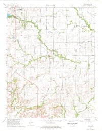 1968 Rose1969 Print · USGSWoodson County in the late sixties shows a landscape of steady agricultural and industrial transition. Researchers can trace the INDIAN TREATY BOUNDARY and locate family history sites like Pleasant Valley Cem and the New York Valley Ch.
 - 1968 Map of Toronto SE, 1969 Print
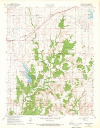 1968 Toronto SE1969 Print · USGSWoodson County's rural townships and oil fields are captured here in the late sixties. Researchers can trace the Old Indian Treaty Boundary and locate local landmarks like Belmont Cem and the rail-side settlement of Batesville.
 - 1969 Map of Yates Center, 1971 Print
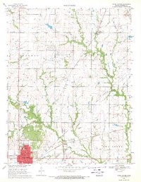 1969 Yates Center1971 Print · USGSWoodson County at the close of the sixties reveals a transition from rail-dependent agriculture to an oil-driven economy. Genealogists can trace family locations near Yates Center, the rural Dutro Cem, or the small community of Durand along the Missouri Pacific line.2 unique versions available
End of results
Showing maps 1-3 of 3
Top cities near Yates Center
Frequently asked questions
- What are the different types of historical maps available for Yates Center?
- What is the oldest map of Yates Center?
- Where can I purchase historical maps of Yates Center for my home or office?
- Where can I download high-res historical maps of Yates Center?
- Are there historical topographic maps available for Yates Center?
- Is there historical aerial imagery available for Yates Center?
- Where are historical maps of Yates Center sourced from?