1900s (20th Century) Maps of Allen County, Kentucky
Explore 33 historic maps of Allen County from the 1900s (20th Century). These maps offer a rare glimpse into what life looked like during the 1900s — showing old roads, neighborhoods, homes, and landmarks that have changed or disappeared over time.
Whether you're researching your family's past, planning a metal detecting trip, or studying how Allen County's landscape evolved across the 1900s, these high-resolution maps are a powerful tool for exploring the history of this region.
- Focus on a specific era: All maps on this page are from the 1900s, giving you a focused view of this time period.
- See what’s changed: Compare century-old streets, trails, and buildings to today's modern landscape using overlays and satellite layers.
- Research with precision: Use these maps for genealogy, historical research, land use analysis, or educational projects.
- View, download, or print: Maps are fully viewable online in high resolution, and can be downloaded or printed for your own records.
Start exploring Allen County's history through authentic maps from the 1900s. This is your window into the past.
Allen County, KY maps
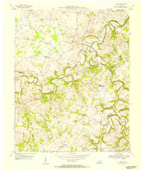
(33)- 1921 Map of Bowling Green, 1955 Print
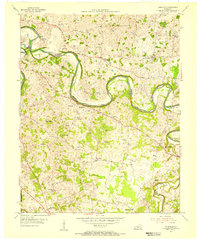
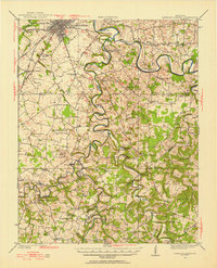 1921 Bowling Green1955 Print · USGSBowling Green and its surrounding counties are shown here just after the Great War, when the Louisville and Nashville railroad fueled regional growth. Genealogists can trace hundreds of family landmarks, from Mussey Mill to schools like Cave Mill School and the remote Antioch Chapel.
 - 1923 Map of Bowling Green
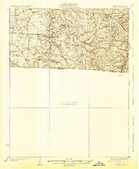
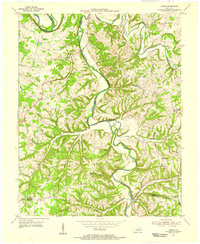
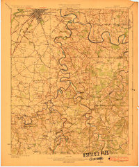 1923 Bowling Green1923 Print · USGSThe Bowling Green area in the early 1920s was a landscape defined by the winding Barren River and the busy Louisville and Nashville Railroad. Researchers can trace ancestral roots through dozens of rural sites like Cassadays Store, Massey Mill, and the Lost River.4 unique versions available
 - 1926 Map of Scottsville
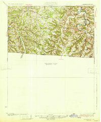
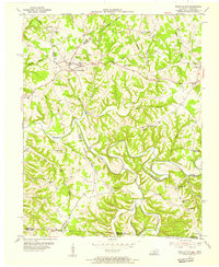
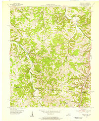
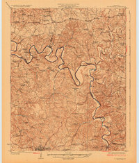 1926 Scottsville1926 Print · USGSThe Barren River valley in the mid-twenties was a landscape of ferries and fords connecting isolated rural schools and churches. Researchers can trace ancestral locations like Scottsville, find the Rocky Hill Game PO, or locate the Rough and Ready School.
 - 1928 Map of Adolphus
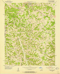
 1928 Adolphus1928 Print · USGSThe Kentucky-Tennessee state line was a landscape of small schools and river crossings in the late twenties. Genealogists can locate family landmarks like Allen Cem, Reeders Sch, and the numerous crossings along Trammel Creek including Old Mill Ford.
 - 1931 Map of Lafayette
 1931 Lafayette1931 Print · USGSThe Kentucky and Tennessee borderlands in the late twenties were a network of tight-knit rural communities connected by winding river hollows. Genealogists and local historians can trace family roots through numerous small landmarks like Austin Sch, Mt Zion Ch, and the settlement of Holland.2 unique versions available
 - 1931 Map of Adolphus
 1931 Adolphus1931 Print · USGSThe Kentucky-Tennessee state line was a landscape of river fords and country schoolhouses during the late Prohibition era. Genealogists can trace family footprints through dozens of local landmarks like Old Mill Ford, McKendree Chapel, and Pinkle Cem.2 unique versions available
 - 1931 Map of Red Boiling Springs
 1931 Red Boiling Springs1931 Print · USGSCrossing the state line during the late twenties, this survey captures a landscape of ridge-top schools and creek-side settlements. Genealogists can trace family footprints through numerous rural landmarks like Sadlers Chapel, Akersville, and Hermitage Springs PO.3 unique versions available
 - 1942 Map of Gallatin
 1942 Gallatin1942 Print · USGSThe Tennessee-Kentucky borderlands were a crossroads of river and rail during the early war years. Genealogists and historians can trace family roots through dozens of named settlements like Bethpage, Prices Mill, and Mitchellville, or locate historic river crossings such as Kirkpatricks Ferry.
 - 1953 Map of Tracy, 1954 Print
 1953 Tracy1954 Print · USGSThe rural borderlands of Barren and Monroe counties come alive in the early 1950s, showing a landscape of family farms and creek-bottom communities. Researchers can locate local landmarks like Cooktown, Tracy, and numerous schools including Antioch Sch.2 unique versions available
 - 1954 Map of Drake, 1955 Print
 1954 Drake1955 Print · USGSSouthern Kentucky farmland and the winding Drakes Creek are captured here in the mid-fifties. Genealogists and local historians can trace small communities like Gold City and Drake P.O. or locate family landmarks such as Barnes Sch and Salem Ch.
 - 1954 Map of Austin, 1955 Print
 1954 Austin1955 Print · USGSThe Barren River hills of rural Kentucky come to life in the mid-1950s, showing a landscape defined by sharp river bends and scattered ridge-top farms. Genealogists can locate old family landmarks like Browns Ford, Pleasant Home Ch, and the Old Austin-Tracy High Sch before modern changes transformed the region.
 - 1954 Map of Fountain Run, 1955 Print
 1954 Fountain Run1955 Print · USGSSouthern Kentucky and northern Tennessee meet along the Barren River in the mid-fifties, showing a rural landscape of ridges and hollows. Genealogists can trace family roots through numerous local landmarks like Fountain Run Sch, Old Rocky Hill Ch, and Akersville.2 unique versions available
 - 1954 Map of Petroleum, 1955 Print
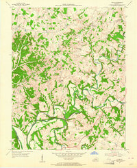
 1954 Petroleum1955 Print · USGSAllen County, Kentucky, supported a thriving rural oil economy in the mid-1950s centered around the namesake town of Petroleum. Researchers can locate numerous active Oil Wells and trace family heritage through sites like White Plains Sch and Mt Pleasant Ch.4 unique versions available
 - 1954 Map of Polkville, 1955 Print
 1954 Polkville1955 Print · USGSWarren and Allen Counties in the mid-fifties reveal a landscape of winding river bends and active petroleum exploration. Genealogists and historians can locate numerous family-named landmarks and rural centers like Hardcastle, Petty Cem, and the Rocky Springs Sch.2 unique versions available
 - 1954 Map of Scottsville, 1955 Print
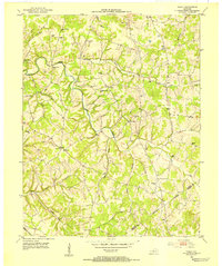
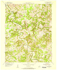
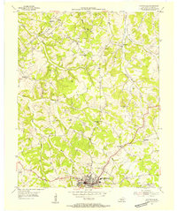 1954 Scottsville1955 Print · USGSAllen County is captured here in the mid-fifties, centered on the activity of the county seat and the surrounding petroleum fields. Genealogists and local historians can trace the rural landscape through a dense concentration of Oil Wells, local landmarks like Clifton Ch, and schoolhouses such as Harrison Sch.4 unique versions available
 - 1954 Map of Meador, 1955 Print
 1954 Meador1955 Print · USGSThe Barren River winds through this rural Kentucky landscape during the mid-1950s, marking the convergence of Warren, Allen, and Barren counties. Local historians can trace family roots through numerous country landmarks like Mt Union Ch, Berry Store, and river crossings at Martinsville Ford.
 - 1954 Map of Holland, 1955 Print
 1954 Holland1955 Print · USGSThe Allen Co Macon Co line and the winding Barren River define this rural landscape during the mid-fifties. Genealogists and local historians can trace family locations through numerous named sites like Mt Zion Sch, Liberty Ch, and the community of Holland.
 - 1954 Map of Hickory Flat, 1956 Print
 1954 Hickory Flat1956 Print · USGSThe Kentucky and Tennessee borderlands in the mid-1950s show a dense network of rural life organized around the Drakes Creek forks. Genealogists can trace family footprints through numerous small landmarks like Bethany Cem, Round Pond Sch, and the community of New Roe.
 - 1954 Map of Adolphus, 1956 Print
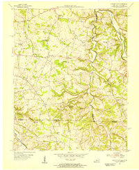
 1954 Adolphus1956 Print · USGSThe Kentucky-Tennessee borderlands in the mid-fifties were defined by tight-knit rural communities and the rail traffic of the Louisville and Nashville. Genealogists can trace family footprints through numerous local landmarks like Walkers Chapel School, Roberts Tabernacle, and Adolphus.2 unique versions available
 - 1954 Map of Allen Springs, 1956 Print
 1954 Allen Springs1956 Print · USGSThe rural boundary of Warren and Allen Counties in the mid-1950s is defined by the winding Trammel Fork and its small farming hamlets. Genealogists and local historians can trace the foundations of communities like Allen Springs and Butlersville, and find landmarks including Halfway Sch and Cave Friendship Ch.2 unique versions available
 - 1954 Map of Lucas, 1964 Print
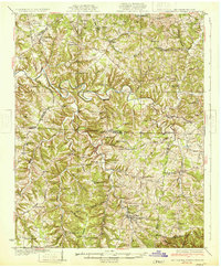
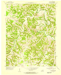
 1954 Lucas1964 Print · USGSThe Barren River valley in the mid-fifties still maintained its intricate network of rural schools and winding creek-side settlements. Genealogists and local historians can trace the foundations of communities like Railton and Lucas or locate landmarks such as Old Zion Ch and the Narrows.
 - 1956 Map of Corbin, 1966 Print
 1956 Corbin1966 Print · USGSThe Kentucky and Tennessee borderlands are captured here in the mid-fifties, showing the region's shift toward modern interstate travel and reservoir development. Genealogists and historians can trace old community lines near Albany and Monticello or locate early rail junctions along the Southern and Tennessee Central lines.3 unique versions available
 - 1956 Map of Nashville, 1971 Print
 1956 Nashville1971 Print · USGSThe Tennessee-Kentucky borderlands come into focus in the mid-1960s as major reservoir projects transformed the Cumberland and Tennessee river valleys. Researchers can trace the rail networks of the Louisville and Nashville and visit sites like Fort Campbell and Fort Donelson National Military Park.2 unique versions available
 - 1958 Map of Corbin
 1958 Corbin1958 Print · USGSThe Upper Cumberland borderlands appear in the late 1950s as massive reservoirs and early atomic-era growth reshape the region. Trace family roots and vanished landmarks near Lake Cumberland, Oak Ridge, and the Cumberland National Forest.
 - 1959 Map of Nashville
 1959 Nashville1959 Print · USGSMiddle Tennessee and Southern Kentucky come into focus during the late fifties, showing the region's transition into a modern transportation and military hub. Researchers can trace the sprawling Fort Campbell Military Reservation or locate historic rail stops along the Tennessee Central Ry and Illinois Central RR.
Showing maps 1-25 of 33
Top cities of Allen County
Frequently asked questions
- What are the different types of historical maps available for Allen County?
- What is the oldest map of Allen County?
- Where can I purchase historical maps of Allen County for my home or office?
- Where can I download high-res historical maps of Allen County?
- Are there historical topographic maps available for Allen County?
- Is there historical aerial imagery available for Allen County?
- Where are historical maps of Allen County sourced from?