1950s Maps of Cave City, Kentucky
Explore 3 historic maps of Cave City from the 1950s. These maps offer a rare glimpse into what life looked like during the 1950s — showing old roads, neighborhoods, homes, and landmarks that have changed or disappeared over time.
Whether you're researching your family's past, planning a metal detecting trip, or studying how Cave City's landscape evolved across the 1950s, these high-resolution maps are a powerful tool for exploring the history of this region.
- Focus on a specific era: All maps on this page are from the 1950s, giving you a focused view of this time period.
- See what’s changed: Compare century-old streets, trails, and buildings to today's modern landscape using overlays and satellite layers.
- Research with precision: Use these maps for genealogy, historical research, land use analysis, or educational projects.
- View, download, or print: Maps are fully viewable online in high resolution, and can be downloaded or printed for your own records.
Start exploring Cave City's history through authentic maps from the 1950s. This is your window into the past.
Cave City, KY maps
(3)- 1954 Map of Horse Cave, 1955 Print
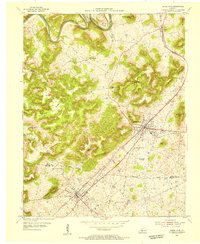 1954 Horse Cave1955 Print · USGSMid-century Kentucky karst country is on full display here, capturing the area between Horse Cave and Cave City at a peak of local rail and road travel. Genealogists and historians can locate numerous rural landmarks like Our Lady of the Caves Ch, Northtown, and the winding Green River loops.2 unique versions available
 - 1954 Map of Glasgow North, 1956 Print
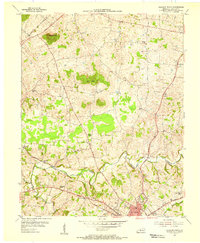 1954 Glasgow North1956 Print · USGSBarren County, Kentucky, thrives in the mid-fifties as a hub of rural commerce and community life anchored by the city of Glasgow. Genealogists and historians can trace family locations through numerous landmarks like Browders Chapel, Sinking Spring Sch, and the Oil Wells of Oil City.
 - 1957 Map of Winchester, 1968 Print
 1957 Winchester1968 Print · USGSCentral Kentucky's landscape in the mid-twentieth century features the sprawling Fort Knox and the early parkway system. Genealogists and historians can trace rail lines like the Southern Railway and find landmarks from Bernheim Forest to Pilot Knob.3 unique versions available
End of results
Showing maps 1-3 of 3
Top cities near Cave City
- Glasgow historical maps
- Horse Cave historical maps
- Munfordville historical maps
- Park City historical maps
Frequently asked questions
- What are the different types of historical maps available for Cave City?
- What is the oldest map of Cave City?
- Where can I purchase historical maps of Cave City for my home or office?
- Where can I download high-res historical maps of Cave City?
- Are there historical topographic maps available for Cave City?
- Is there historical aerial imagery available for Cave City?
- Where are historical maps of Cave City sourced from?