1940s Maps of Irvington, Kentucky
Explore 3 historic maps of Irvington from the 1940s. These maps offer a rare glimpse into what life looked like during the 1940s — showing old roads, neighborhoods, homes, and landmarks that have changed or disappeared over time.
Whether you're researching your family's past, planning a metal detecting trip, or studying how Irvington's landscape evolved across the 1940s, these high-resolution maps are a powerful tool for exploring the history of this region.
- Focus on a specific era: All maps on this page are from the 1940s, giving you a focused view of this time period.
- See what’s changed: Compare century-old streets, trails, and buildings to today's modern landscape using overlays and satellite layers.
- Research with precision: Use these maps for genealogy, historical research, land use analysis, or educational projects.
- View, download, or print: Maps are fully viewable online in high resolution, and can be downloaded or printed for your own records.
Start exploring Irvington's history through authentic maps from the 1940s. This is your window into the past.
Irvington, KY maps
(3)- 1947 Map of Irvington
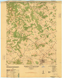 1947 Irvington1947 Print · USGSIn the post-war Kentucky countryside, this survey captures the rural landscape centered on the rail hub of Irvington. Genealogists and historians can trace local farm life and community ties through landmarks like Payneville School, Fairmont School, and Sirocco.
 - 1947 Map of Garfield
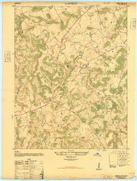 1947 Garfield1947 Print · USGSBreckinridge County is shown just after the war when small farming communities were connected by winding ridge roads. Genealogists and local historians can locate early landmarks like Bethel School, the Old Rock Mine, and the crossroads of Garfield.
 - 1947 Map of Hardinsburg, 1959 Print
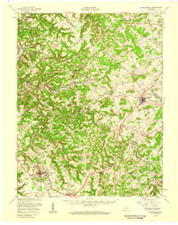 1947 Hardinsburg1959 Print · USGSBreckinridge and Meade Counties are shown here during the late 1940s, a time when rural life centered on local crossroads and one-room schools. Genealogists can trace family connections to landmarks like Fate Chapel, Clifton Mills, or the Bunker Hill Sch.
End of results
Showing maps 1-3 of 3
Top cities near Irvington
- Hardinsburg historical maps
- Brandenburg historical maps
- Ekron historical maps
- Mauckport historical maps
- Laconia historical maps
- New Amsterdam historical maps
Frequently asked questions
- What are the different types of historical maps available for Irvington?
- What is the oldest map of Irvington?
- Where can I purchase historical maps of Irvington for my home or office?
- Where can I download high-res historical maps of Irvington?
- Are there historical topographic maps available for Irvington?
- Is there historical aerial imagery available for Irvington?
- Where are historical maps of Irvington sourced from?