1970s Maps of Butler County, Kentucky
Explore 6 historic maps of Butler County from the 1970s. These maps offer a rare glimpse into what life looked like during the 1970s — showing old roads, neighborhoods, homes, and landmarks that have changed or disappeared over time.
Whether you're researching your family's past, planning a metal detecting trip, or studying how Butler County's landscape evolved across the 1970s, these high-resolution maps are a powerful tool for exploring the history of this region.
- Focus on a specific era: All maps on this page are from the 1970s, giving you a focused view of this time period.
- See what’s changed: Compare century-old streets, trails, and buildings to today's modern landscape using overlays and satellite layers.
- Research with precision: Use these maps for genealogy, historical research, land use analysis, or educational projects.
- View, download, or print: Maps are fully viewable online in high resolution, and can be downloaded or printed for your own records.
Start exploring Butler County's history through authentic maps from the 1970s. This is your window into the past.
Butler County, KY maps
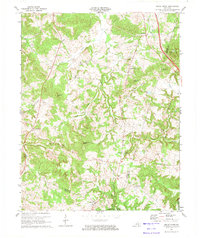
(6)- 1971 Map of Rosine, 1972 Print
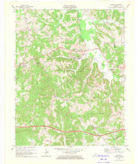 1971 Rosine1972 Print · USGSNear the dawn of the seventies, this survey of central Ohio County captures the rural intersection of rail and road. Genealogists can trace family names through Baizetown Cem, Hopewell Ch, and McCord Cem while following the Illinois Central through Rosine.
 - 1971 Map of Spring Lick, 1973 Print
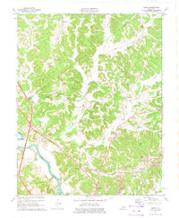
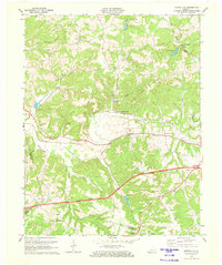 1971 Spring Lick1973 Print · USGSWestern Kentucky’s rural landscape is captured here in the early seventies, showing the meeting point of Grayson, Ohio, and Butler counties. Researchers can trace the Illinois Central Railroad through Spring Lick or locate local landmarks like Smalls Grove Ch and Pine Knob.
 - 1971 Map of Cromwell, 1973 Print
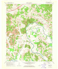 1971 Cromwell1973 Print · USGSThe Green River valley at the start of the 1970s shows a landscape transitioning between traditional river life and modern industrial expansion. Local researchers can trace family homesteads near Shultztown, locate the Southern Sch, or find vanished crossings like Reeds Ferry.
 - 1973 Map of Morgantown, 1974 Print
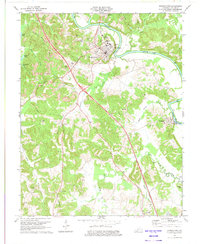 1973 Morgantown1974 Print · USGSMorgantown and the Green River corridor are captured here in the early 1970s, as new parkway construction began to bisect the traditional mining and farming landscape. Genealogists can locate family names and burial sites at Riverview Cem, Hill Haven Memory Gardens, and Sandy Creek Cem.
 - 1973 Map of Sugar Grove, 1974 Print
 1973 Sugar Grove1974 Print · USGSThe rural borderlands of Butler and Warren counties are captured here in the early 1970s, showcasing a landscape of dispersed family farms and wooded ridges. Genealogists can locate family-named sites like McKinney Cem and local centers such as Sugar Grove and Richelieu.
 - 1973 Map of Flener, 1974 Print
 1973 Flener1974 Print · USGSButler and Ohio County life in the early seventies centered on the ridges between the Green River and Indian Camp Creek. Researchers can locate family landmarks like Flener Chapel, the Fifth District Sch, and the Strip Mine sites near Monford.2 unique versions available
End of results
Showing maps 1-6 of 6
Top cities of Butler County
Frequently asked questions
- What are the different types of historical maps available for Butler County?
- What is the oldest map of Butler County?
- Where can I purchase historical maps of Butler County for my home or office?
- Where can I download high-res historical maps of Butler County?
- Are there historical topographic maps available for Butler County?
- Is there historical aerial imagery available for Butler County?
- Where are historical maps of Butler County sourced from?