1960s Maps of Princeton, Kentucky
Explore 5 historic maps of Princeton from the 1960s. These maps offer a rare glimpse into what life looked like during the 1960s — showing old roads, neighborhoods, homes, and landmarks that have changed or disappeared over time.
Whether you're researching your family's past, planning a metal detecting trip, or studying how Princeton's landscape evolved across the 1960s, these high-resolution maps are a powerful tool for exploring the history of this region.
- Focus on a specific era: All maps on this page are from the 1960s, giving you a focused view of this time period.
- See what’s changed: Compare century-old streets, trails, and buildings to today's modern landscape using overlays and satellite layers.
- Research with precision: Use these maps for genealogy, historical research, land use analysis, or educational projects.
- View, download, or print: Maps are fully viewable online in high resolution, and can be downloaded or printed for your own records.
Start exploring Princeton's history through authentic maps from the 1960s. This is your window into the past.
Princeton, KY maps
(5)- 1961 Map of Evansville
 1961 Evansville1961 Print · USGSThe Ohio River valley and its surrounding coalfields are captured here during the late fifties and early sixties. Trace the industrial rail networks of the Illinois Central RR and explore regional landmarks like Mammoth Cave National Park and Angel Mounds State Memorial.2 unique versions available
 - 1967 Map of Princeton East, 1969 Print
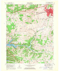
 1967 Princeton East1969 Print · USGSCaldwell County in the late sixties shows a landscape shaped by the Illinois Central railroad and a network of rural settlements. Genealogists can locate family names at Wadlington and Dunning cemeteries or trace landmarks like Pumpkin Center and Otter Pond.
 - 1967 Map of Crider, 1969 Print
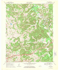
 1967 Crider1969 Print · USGSWestern Kentucky's ridge country is captured in the late sixties as the Western Kentucky Pkwy arrives near Crider. Genealogists can trace family names at Bethlehem Cem, Adamson Cem, and White Sulphur Ch.
 - 1967 Map of Princeton West, 1970 Print
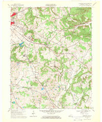
 1967 Princeton West1970 Print · USGSIn the late 1960s, the growing town of Princeton and the emerging waters of Lake Barkley highlight the changing landscape of western Kentucky. Genealogists and local historians can trace legacy sites like the Beck Cemetery, Dulaney, and several country schools including Southside School.
 - 1967 Map of Olney, 1970 Print
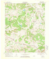
 1967 Olney1970 Print · USGSCaldwell County in the late sixties shows a landscape where the new Western Kentucky Parkway meets established river life. Researchers can locate numerous family cemeteries like Creekmur Bridge Cem and trace the old Illinois Central Railroad as it passes near Lewistown.
End of results
Showing maps 1-5 of 5
Top cities near Princeton
- Marion historical maps
- Cadiz historical maps
- Dawson Springs historical maps
- Eddyville historical maps
- Kuttawa historical maps
- Fredonia historical maps
Top neighborhoods of Princeton
Frequently asked questions
- What are the different types of historical maps available for Princeton?
- What is the oldest map of Princeton?
- Where can I purchase historical maps of Princeton for my home or office?
- Where can I download high-res historical maps of Princeton?
- Are there historical topographic maps available for Princeton?
- Is there historical aerial imagery available for Princeton?
- Where are historical maps of Princeton sourced from?