1950s Maps of Princeton, Kentucky
Explore 6 historic maps of Princeton from the 1950s. These maps offer a rare glimpse into what life looked like during the 1950s — showing old roads, neighborhoods, homes, and landmarks that have changed or disappeared over time.
Whether you're researching your family's past, planning a metal detecting trip, or studying how Princeton's landscape evolved across the 1950s, these high-resolution maps are a powerful tool for exploring the history of this region.
- Focus on a specific era: All maps on this page are from the 1950s, giving you a focused view of this time period.
- See what’s changed: Compare century-old streets, trails, and buildings to today's modern landscape using overlays and satellite layers.
- Research with precision: Use these maps for genealogy, historical research, land use analysis, or educational projects.
- View, download, or print: Maps are fully viewable online in high resolution, and can be downloaded or printed for your own records.
Start exploring Princeton's history through authentic maps from the 1950s. This is your window into the past.
Princeton, KY maps
(6)- 1954 Map of Evansville
 1954 Evansville1954 Print · USGSThe Ohio River borderlands between Indiana and Kentucky appear here during a period of robust industrial and military growth. Genealogists and researchers can trace the rail corridors of the Illinois Central and find landmarks like US Lock and Dam No 48 or Camp Breckinridge.
 - 1954 Map of Princeton West, 1955 Print
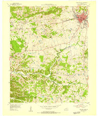 1954 Princeton West1955 Print · USGSCaldwell County at the mid-century mark centers on the growing hub of Princeton and the busy ILLINOIS CENTRAL rail line. Researchers can trace rural lineages through numerous local landmarks like Friendship Ch, Dotson Sch, and Caldwell Cem.
 - 1954 Map of Olney, 1955 Print
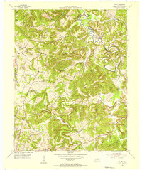 1954 Olney1955 Print · USGSCaldwell and Hopkins counties meet along the Tradewater River in the mid-1950s, a period of quiet rural life and deep-rooted family farms. Genealogists can trace family names across a landscape filled with landmarks like Grower Cem, McGregor Cem, and the settlement of Lewistown.
 - 1954 Map of Princeton East, 1955 Print
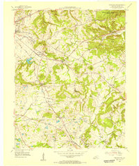 1954 Princeton East1955 Print · USGSCaldwell County's agrarian and industrial landscape comes into focus during the mid-fifties as the railroad and quarrying operations drive local growth. Researchers can trace dozens of family cemeteries like Tandy Cem and rural nodes like Scottsburg or Harmony Ch.2 unique versions available
 - 1954 Map of Crider, 1955 Print
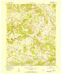 1954 Crider1955 Print · USGSCaldwell County in the mid-fifties is a landscape of hilltop farms and active mineral extraction. Genealogists can trace family lines through dozens of rural sites like Asher Cem, Bethany Ch, and the active Williamson Mines near Crider.
 - 1957 Map of Evansville, 1969 Print
 1957 Evansville1969 Print · USGSIndiana and Kentucky meet along the Ohio River in this mid-century survey of a vital industrial and transport corridor. Genealogists and historians can trace the development of river towns like Owensboro and Newburgh or locate old rail lines like the Southern Ry.3 unique versions available
End of results
Showing maps 1-6 of 6
Top cities near Princeton
- Marion historical maps
- Cadiz historical maps
- Dawson Springs historical maps
- Eddyville historical maps
- Kuttawa historical maps
- Fredonia historical maps
Top neighborhoods of Princeton
Frequently asked questions
- What are the different types of historical maps available for Princeton?
- What is the oldest map of Princeton?
- Where can I purchase historical maps of Princeton for my home or office?
- Where can I download high-res historical maps of Princeton?
- Are there historical topographic maps available for Princeton?
- Is there historical aerial imagery available for Princeton?
- Where are historical maps of Princeton sourced from?