1970s Maps of Elliott County, Kentucky
Explore 6 historic maps of Elliott County from the 1970s. These maps offer a rare glimpse into what life looked like during the 1970s — showing old roads, neighborhoods, homes, and landmarks that have changed or disappeared over time.
Whether you're researching your family's past, planning a metal detecting trip, or studying how Elliott County's landscape evolved across the 1970s, these high-resolution maps are a powerful tool for exploring the history of this region.
- Focus on a specific era: All maps on this page are from the 1970s, giving you a focused view of this time period.
- See what’s changed: Compare century-old streets, trails, and buildings to today's modern landscape using overlays and satellite layers.
- Research with precision: Use these maps for genealogy, historical research, land use analysis, or educational projects.
- View, download, or print: Maps are fully viewable online in high resolution, and can be downloaded or printed for your own records.
Start exploring Elliott County's history through authentic maps from the 1970s. This is your window into the past.
Elliott County, KY maps
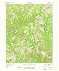
(6)- 1970 Map of Olive Hill, 1972 Print
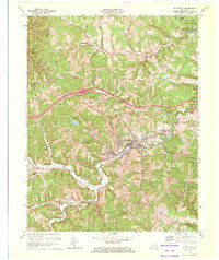 1970 Olive Hill1972 Print · USGSThe Tygarts Creek valley in the 1970s shows a landscape shaped by the Chesapeake and Ohio rail line. Trace family roots and local industry through Olive Hill, Soldier, and Lawton, or locate rural landmarks like Rose Chapel.2 unique versions available
 - 1970 Map of Willard, 1972 Print
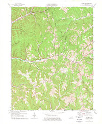
 1970 Willard1972 Print · USGSEastern Kentucky's hill country at the start of the 1970s shows a landscape of ridge-top settlements and coal-country hollows. Genealogists and historians can locate family landmarks like Hensley Cem and Kitchen Cem, or trace the mining history near Willard and Jeriel.2 unique versions available
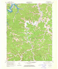
 - 1971 Map of Bruin, 1972 Print
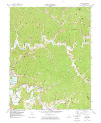
 1971 Bruin1972 Print · USGSThe headwaters of Grayson Lake in the early 1970s reveal a landscape of rural crossroads and narrow river hollers. Researchers can trace family homesteads near Ibex, Newfoundland, and the Pine Springs Ch, or locate old industrial sites like the Mines and Oil Wells along the ridges.2 unique versions available
 - 1977 Map of Haldeman
 1977 Haldeman1977 Print · USGSThe ridges of Rowan and Carter County are shown in the late seventies as the timber and mining landscape matured. Genealogists can trace family names through landmarks like Christian Cem, Slabcamp Ch, and the rail stops at Hays Crossing.
 - 1977 Map of Wrigley
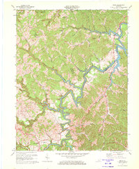
 1977 Wrigley1977 Print · USGSThe Licking River valley in Morgan and Elliott counties is captured here in the late seventies. Family historians and researchers can locate Blairs Mills, the Jones Cem, and rural congregations at Oak Hill Ch.2 unique versions available
 - 1977 Map of Lenox, 1978 Print
 1977 Lenox1978 Print · USGSMorgan County is shown in the late seventies as a landscape of deep river bends and high knobs. Researchers can trace family names through numerous landmarks like Cottle Cem, Gordon Ford, and the Lick Branch Community Ctr.
End of results
Showing maps 1-6 of 6
Top cities of Elliott County
Frequently asked questions
- What are the different types of historical maps available for Elliott County?
- What is the oldest map of Elliott County?
- Where can I purchase historical maps of Elliott County for my home or office?
- Where can I download high-res historical maps of Elliott County?
- Are there historical topographic maps available for Elliott County?
- Is there historical aerial imagery available for Elliott County?
- Where are historical maps of Elliott County sourced from?