Old Maps of Elliott County, Kentucky for Academic Research
Study the evolution of Elliott County with 94 high-resolution historic maps. Whether you're teaching, researching, or modeling changes in land use, these maps provide essential visual documentation of urban, environmental, and geographic change.
- Analyze long-term change: Track patterns in development, transportation, and natural features.
- Ideal for environmental or urban studies: Support academic projects with primary historical map data.
- Use in the classroom or lab: Educators and researchers rely on these maps to bring historical context to life.
These maps are a powerful tool for teaching, research, and visualizing how Elliott County has changed over the decades.
Elliott County, KY maps
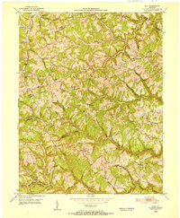
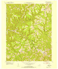
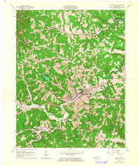
(94)- 1889 Map of Salyersville, 1949 Print
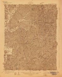
 1889 Salyersville1949 Print · USGSEastern Kentucky at the close of the nineteenth century reveals a complex landscape of river-valley settlements and highland hollows. Genealogists can trace early homesteads and communities like Salyersville, Hazel Green, and Jackson along the winding Licking River and Quicksand Creek.
 - 1891 Map of Salyersville
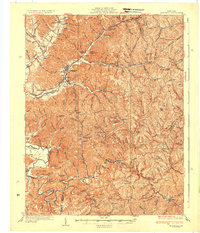
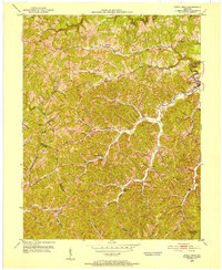
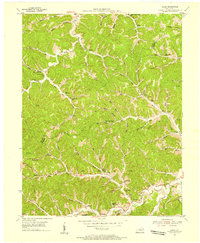
 1891 Salyersville1891 Print · USGSEastern Kentucky's rugged plateau is captured in the late nineteenth century as small river towns and remote hollows defined the region. Genealogists can trace family roots through mountain settlements like Salyersville, Hazel Green, and Maytown along the Licking River.2 unique versions available
 - 1899 Map of Salyersville
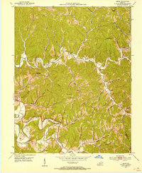
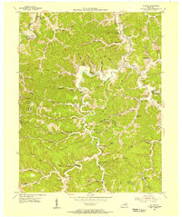
 1899 Salyersville1899 Print · USGSEastern Kentucky's mountain communities were well-established along the winding river forks at the turn of the century. Genealogists and local historians can trace family-named landmarks and old settlements like Hazel Green, Ezel, and West Liberty along the Licking River.4 unique versions available
 - 1903 Map of Kenova
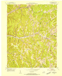
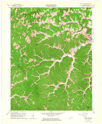
 1903 Kenova1903 Print · USGSThe tri-state river junction at Ashland and Kenova was a bustling industrial hub after the turn of the century. Trace early rail lines and mining settlements like Coalton and Boghead, or locate family landmarks along the Little Sandy River and Means Tunnel.5 unique versions available
 - 1904 Map of Kenova
 1904 Kenova1904 Print · USGSThe tri-state confluence of the Ohio River and Big Sandy River hums with early industrial activity at the start of the century. Genealogists can trace rail-side settlements and remote homesteads along Blaine Creek and near Mt Savage or Webbville.
 - 1929 Map of Morehead
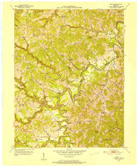
 1929 Morehead1929 Print · USGSRowan and Morgan counties were centers of rail and clay production when this late-1920s survey was conducted. Local historians can locate early post offices like Elliottville PO (Hogtown) and trace the paths of the Chesapeake and Ohio through the Clack Mtn Tunnel.
 - 1935 Map of Morehead
 1935 Morehead1935 Print · USGSIn the mid-1930s, the mountain hollows around Morehead were connected by a dense network of country schools and the Chesapeake and Ohio railroad. Trace family sites at Blairs Mills PO, Zilpo, and the tunnels through Clack Mountain.
 - 1950 Map of Bruin, 1952 Print
 1950 Bruin1952 Print · USGSElliott and Carter counties in the early fifties show a landscape of deep hollows and winding creek-bottom settlements. Researchers can locate many family cemeteries and rural school sites such as Ibex Waddell Sch and Flannery Cem along the Little Sandy River.
 - 1950 Map of Isonville, 1952 Print
 1950 Isonville1952 Print · USGSMid-century Elliott County is mapped here during a period of active rural life and early oil exploration. Researchers can trace ancestral locations through numerous schools like Fairview Sch and landmarks including Peters Hill Lookout Tower and Isonville.
 - 1950 Map of Olive Hill, 1952 Print
 1950 Olive Hill1952 Print · USGSMid-century Carter County comes alive in this survey of the Olive Hill area, where the river-and-rail economy of the Appalachians is on full display. Genealogists and historians can trace family-named ridges and hollows, locating old landmarks like Erie College, James Chapel, and the settlement of Soldier.
 - 1950 Map of Ault, 1952 Print
 1950 Ault1952 Print · USGSNortheastern Kentucky life in the early fifties revolves around winding creek-beds and ridge-top schools. Trace ancestral roots through localized landmarks like Gimlet (PO), Mocabee Ford, and the many rural schools including Rock Springs Sch and Bunker Hill Sch.
 - 1950 Map of Sandy Hook, 1952 Print
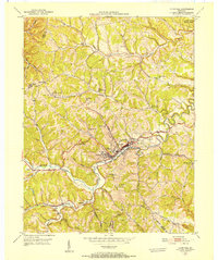
 1950 Sandy Hook1952 Print · USGSThe hills of Elliott County were home to a dense network of valley settlements and country schools in the early fifties. Genealogists can trace family-named landmarks and rural hubs like Sandy Hook, Redwine, and Fannin Sch.
 - 1950 Map of Lenox, 1953 Print
 1950 Lenox1953 Print · USGSMorgan County in the early fifties is captured here through its intricate river valleys and remote ridge-top settlements. Researchers can locate numerous family-named landmarks like Adkins Cem, the community at Cottle Bend, and the historic Gordon Ford.
 - 1951 Map of Dingus, 1953 Print
 1951 Dingus1953 Print · USGSThe Morgan County backcountry in the early fifties reveals a network of tight-knit hollows defined by the coal and creek-bottom economy. Researchers can trace family history through numerous rural landmarks like Peddler Gap Sch, Lenton Ch, and the Daniel Cem.
 - 1951 Map of Lenox, 1953 Print
 1951 Lenox1953 Print · USGSMorgan County's river valleys and ridgelines are captured here in the early fifties, showing a rural landscape organized around its creeks and hollows. Genealogists can locate family landmarks like Cottle Cem, Patton Cem, and the crossing at Gordon Ford.2 unique versions available
 - 1953 Map of Haldeman, 1954 Print
 1953 Haldeman1954 Print · USGSRowan County in the early 1950s is shown here as a landscape of rural schools and winding creek valleys. Researchers can trace the Chesapeake and Ohio rail line or locate community hubs like Haldeman, Elliottville, and the Oak Grove Ch.2 unique versions available
 - 1953 Map of Wrigley, 1954 Print
 1953 Wrigley1954 Print · USGSEastern Kentucky's mountain communities were still centered on local valley schools and remote post offices in the early fifties. Genealogists and historians can trace family locations through Blairs Mills Sch, Oak Hill Sch, and the settlement at Wrigley.2 unique versions available
 - 1953 Map of Mazie, 1955 Print
 1953 Mazie1955 Print · USGSLawrence and Elliott Counties in the early 1950s reveal a landscape of ridge-top farms and creek-bottom communities. Genealogists can locate family landmarks like the Jason Boggs Cemetery, Mazie Church, and the widespread Gas and Oil Field.3 unique versions available
 - 1953 Map of Willard, 1955 Print
 1953 Willard1955 Print · USGSThe hill country of Carter and Lawrence counties is captured here in the early fifties as small mining and farming communities lined the Little Sandy River. Local researchers can locate family landmarks like Kitchen Cem, several rural schoolhouses, and industrial sites such as E K Mines Br.2 unique versions available
 - 1957 Map of Huntington, 1966 Print
 1957 Huntington1966 Print · USGSThe industrial heart of the Ohio River valley is captured here in the mid-sixties, showing the growth of Huntington and Ashland. Researchers can trace the extensive rail networks of the Chesapeake and Ohio RR and locate sites like the Chief Cornstalk Hunting Ground.3 unique versions available
 - 1957 Map of Jenkins, 1974 Print
 1957 Jenkins1974 Print · USGSThe Cumberland Plateau in the mid-twentieth century reveals a complex landscape of winding river valleys and deep-seated industry. Genealogists and historians can trace the development of Hazard, Jenkins, and Pikeville alongside extensive Numerous Oil and Gas Fields and the routes of the Chesapeake & Ohio Railway.
 - 1960 Map of Jenkins
 1960 Jenkins1960 Print · USGSEastern Kentucky and the West Virginia borderlands are captured at a mid-century peak of the coal and rail era. Trace the industrial corridors of the Chesapeake and Ohio RR through mountain hubs like Hazard and Jenkins.
 - 1960 Map of Huntington
 1960 Huntington1960 Print · USGSThe tri-state river valley thrived in the late fifties as a hub of heavy industry and Appalachian rail transit. Genealogists and historians can trace the connection between river towns like Ashland and Portsmouth or locate family homesteads near Coleman Ridge.
 - 1962 Map of Sandy Hook, 1964 Print
 1962 Sandy Hook1964 Print · USGSSandy Hook and the surrounding hollows of Elliott County are captured here in the early sixties. Genealogists and historians can trace family-named locations such as Neal Howard Creek and find rural landmarks like Carter Sch or Bell City.4 unique versions available
 - 1962 Map of Olive Hill, 1964 Print
 1962 Olive Hill1964 Print · USGSOlive Hill and the surrounding rural hollows of Carter County are shown in detail during the early 1960s. Researchers can trace the path of the Chesapeake and Ohio railroad through old communities like Lawton and Globe.
Showing maps 1-25 of 94
Top cities of Elliott County
Frequently asked questions
- What are the different types of historical maps available for Elliott County?
- What is the oldest map of Elliott County?
- Where can I purchase historical maps of Elliott County for my home or office?
- Where can I download high-res historical maps of Elliott County?
- Are there historical topographic maps available for Elliott County?
- Is there historical aerial imagery available for Elliott County?
- Where are historical maps of Elliott County sourced from?