1930s Maps of Hardin County, Kentucky
Explore 6 historic maps of Hardin County from the 1930s. These maps offer a rare glimpse into what life looked like during the 1930s — showing old roads, neighborhoods, homes, and landmarks that have changed or disappeared over time.
Whether you're researching your family's past, planning a metal detecting trip, or studying how Hardin County's landscape evolved across the 1930s, these high-resolution maps are a powerful tool for exploring the history of this region.
- Focus on a specific era: All maps on this page are from the 1930s, giving you a focused view of this time period.
- See what’s changed: Compare century-old streets, trails, and buildings to today's modern landscape using overlays and satellite layers.
- Research with precision: Use these maps for genealogy, historical research, land use analysis, or educational projects.
- View, download, or print: Maps are fully viewable online in high resolution, and can be downloaded or printed for your own records.
Start exploring Hardin County's history through authentic maps from the 1930s. This is your window into the past.
Hardin County, KY maps
(6)- 1932 Map of Big Clifty
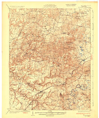 1932 Big Clifty1932 Print · USGSGrayson and Hardin Counties are captured here between the World Wars, showing a rural landscape defined by the Illinois Central Railroad and the Dixie Highway. Genealogists and historians can locate dozens of small community centers like Big Clifty, White Mills, and the Asphalt Mine.5 unique versions available
 - 1934 Map of Munfordville
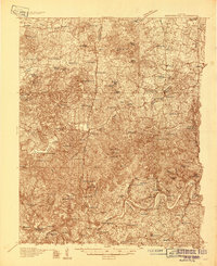 1934 Munfordville1934 Print · USGSHart County communities line the corridor of the Green River and the Nashville Road during the mid-1930s. Genealogists can trace family footprints through dozens of local landmarks like Poundstone Roller Mill, Big Springs Cem, and Priceville.
 - 1935 Map of Elizabethtown
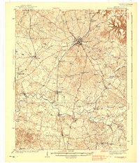
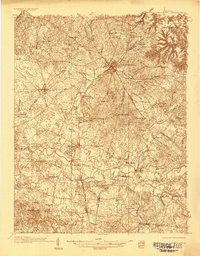 1935 Elizabethtown1935 Print · USGSElizabethtown and the surrounding Hardin County rural landscape are captured here in the mid-1930s. Researchers can trace family roots through a dense network of country schools and churches like Glendale Sch, St Ignatius Ch, and Bland Cem.
 - 1936 Map of Vine Grove
 1936 Vine Grove1936 Print · USGSHardin and Bullitt counties are shown here during a period of massive military expansion before the mid-century. Researchers can trace the development of Fort Knox alongside established communities like Vine Grove and old rural landmarks like Stovall Chapel or the Glenbeddis Sch.
 - 1937 Map of Munfordville
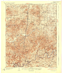 1937 Munfordville1937 Print · USGSThe Green River valley in the 1930s was a landscape of river fords and knob-country schools. Genealogists can trace family footprints across dozens of local sites like Falling Springs Ch, Big Springs Cem, and the old Rider Mill.
 - 1938 Map of Elizabethtown
 1938 Elizabethtown1938 Print · USGSHardin and Larue counties are shown here in the 1930s, captured at the height of the steam-rail era. Genealogists can trace family names through dozens of rural landmarks, from Mather Mill and Star Mills to St Ignatius Ch and the Childrens Home.3 unique versions available
End of results
Showing maps 1-6 of 6
Top cities of Hardin County
- Elizabethtown historical maps
- Radcliff historical maps
- Vine Grove historical maps
- Rineyville historical maps
- Sonora historical maps
Frequently asked questions
- What are the different types of historical maps available for Hardin County?
- What is the oldest map of Hardin County?
- Where can I purchase historical maps of Hardin County for my home or office?
- Where can I download high-res historical maps of Hardin County?
- Are there historical topographic maps available for Hardin County?
- Is there historical aerial imagery available for Hardin County?
- Where are historical maps of Hardin County sourced from?