1970s Maps of Hardin County, Kentucky
Explore 4 historic maps of Hardin County from the 1970s. These maps offer a rare glimpse into what life looked like during the 1970s — showing old roads, neighborhoods, homes, and landmarks that have changed or disappeared over time.
Whether you're researching your family's past, planning a metal detecting trip, or studying how Hardin County's landscape evolved across the 1970s, these high-resolution maps are a powerful tool for exploring the history of this region.
- Focus on a specific era: All maps on this page are from the 1970s, giving you a focused view of this time period.
- See what’s changed: Compare century-old streets, trails, and buildings to today's modern landscape using overlays and satellite layers.
- Research with precision: Use these maps for genealogy, historical research, land use analysis, or educational projects.
- View, download, or print: Maps are fully viewable online in high resolution, and can be downloaded or printed for your own records.
Start exploring Hardin County's history through authentic maps from the 1970s. This is your window into the past.
Hardin County, KY maps
(4)- 1972 Map of Big Clifty, 1973 Print
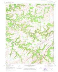 1972 Big Clifty1973 Print · USGSGrayson County in the early 1970s shows a landscape of winding river valleys and rural crossroads. Genealogists can trace family names through St Paul's Cemetery and locate former educational sites like Goodman School and Western Consolidated School.
 - 1972 Map of Summit, 1974 Print
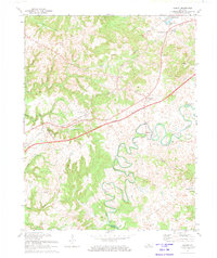 1972 Summit1974 Print · USGSHardin County's karst landscape and river valleys are captured here in the early seventies, showing a rural community balanced between rail history and new parkway development. Researchers can trace family roots at Duncan Cem and locate landmarks like White Mills or the Wonderland Cavern.
 - 1979 Map of Tonieville, 1983 Print
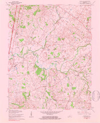 1979 Tonieville1983 Print · USGSIn the rolling hills of Larue and Hardin County during the mid-twentieth century, the Nolin River served as the backbone for rural life. Genealogists and historians can trace the foundations of local families at Big Spring Cem, the railway connections at Glendale Junction, and old milling sites like Mathers Mills.
 - 1979 Map of Upton, 1984 Print
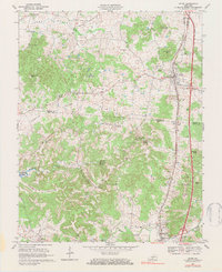 1979 Upton1984 Print · USGSThe Kentucky rail-and-road corridor between Hardin and Hart Counties is captured here during the late seventies. Researchers can trace rural life through sites like Riders Mill, the Louisville and Nashville railroad, and dozens of family cemeteries like Brashear Cem.
End of results
Showing maps 1-4 of 4
Top cities of Hardin County
- Elizabethtown historical maps
- Radcliff historical maps
- Vine Grove historical maps
- Rineyville historical maps
- Sonora historical maps
Frequently asked questions
- What are the different types of historical maps available for Hardin County?
- What is the oldest map of Hardin County?
- Where can I purchase historical maps of Hardin County for my home or office?
- Where can I download high-res historical maps of Hardin County?
- Are there historical topographic maps available for Hardin County?
- Is there historical aerial imagery available for Hardin County?
- Where are historical maps of Hardin County sourced from?