1940s Maps of Hardin County, Kentucky
Explore 21 historic maps of Hardin County from the 1940s. These maps offer a rare glimpse into what life looked like during the 1940s — showing old roads, neighborhoods, homes, and landmarks that have changed or disappeared over time.
Whether you're researching your family's past, planning a metal detecting trip, or studying how Hardin County's landscape evolved across the 1940s, these high-resolution maps are a powerful tool for exploring the history of this region.
- Focus on a specific era: All maps on this page are from the 1940s, giving you a focused view of this time period.
- See what’s changed: Compare century-old streets, trails, and buildings to today's modern landscape using overlays and satellite layers.
- Research with precision: Use these maps for genealogy, historical research, land use analysis, or educational projects.
- View, download, or print: Maps are fully viewable online in high resolution, and can be downloaded or printed for your own records.
Start exploring Hardin County's history through authentic maps from the 1940s. This is your window into the past.
Hardin County, KY maps
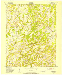
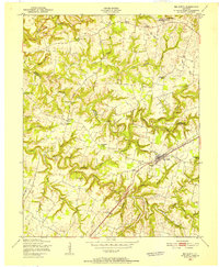
(21)- 1941 Map of Ekron
 1941 Ekron1941 Print · USGSNorthern Kentucky and the Ohio River shoreline are captured here in the early 1940s, showing the rural communities of Meade and Hardin Counties. Genealogists can trace family locations near Ekron, Shumate School, and the historic Sherman Landing.
 - 1943 Map of Vine Grove
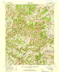
 1943 Vine Grove1943 Print · USGSHardin and Meade Counties appear here during a period of massive mid-century growth at Fort Knox. Genealogists can trace family homesteads near landmarks like Stovall Chapel, Red Hill, and the many rural schools including Hays Sch and Deckard Sch.
 - 1946 Map of Pitts Point
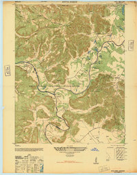 1946 Pitts Point1946 Print · USGSIn the mid-1940s, this area of Bullitt and Hardin County was transforming into a vital military landscape. Genealogists can locate numerous community landmarks like Hays School, Stowers Branch Cem, and the river junction at Pitts Point.
 - 1946 Map of Fort Knox
 1946 Fort Knox1946 Print · USGSFort Knox and the surrounding Kentucky riverlands are captured just after the war as the military installation reached its modern maturity. Researchers can trace the layout of Godman Field, locate the famous Bullion Depository, and find family landmarks like Montgomery Cem or the town of West Point.
 - 1946 Map of Colesburg
 1946 Colesburg1946 Print · USGSHardin and Bullitt Counties are shown at a transitional post-war moment when military activity and rural Kentucky life intersected. Researchers can locate the Fort Knox Military Reservation alongside older landmarks like Zion School and Mather Cem.
 - 1946 Map of Vine Grove
 1946 Vine Grove1946 Print · USGSHardin County settlements and the southern edge of Fort Knox are frozen in time just after the war. Researchers can locate family landmarks such as Lincoln Memorial Cem, the Illinois Central rail line, and the village of Vine Grove.
 - 1946 Map of Vine Grove, 1959 Print
 1946 Vine Grove1959 Print · USGSMid-century Hardin County is defined by the massive expansion of the Fort Knox Military Reservation and its surrounding rail-and-highway hubs. Researchers can trace dozens of family cemeteries and vanished landmarks like the Woolridge Ferry Bridge, Sherrard Sch, and the community of Pitts Point.
 - 1947 Map of Ekron, 1959 Print
 1947 Ekron1959 Print · USGSMeade County and the riverfronts of the Ohio Valley come alive in this late 1940s survey. Genealogists and historians can trace the foundations of Garnettsville, locate rural landmarks like Doe Run Mill, or search for family connections at Cedar Farm Cem and St Martins Sch.
 - 1948 Map of Flaherty
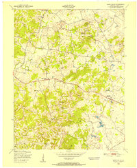
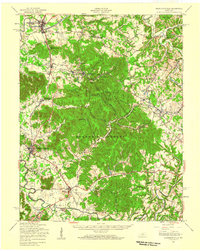
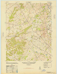 1948 Flaherty1948 Print · USGSMid-century Hardin County reveals a landscape of upland farms and rural schools shortly after the war. Genealogists can trace family roots at St Martins Church Cem and School, Salem Church and Cemetery, and the old Miller School.
 - 1948 Map of Big Spring
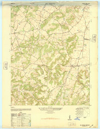 1948 Big Spring1948 Print · USGSKentucky's rural interior comes into focus shortly after the war, showing the tight-knit network of country roads and family-named corners. Genealogists can trace property and community life near Bewleyville School, High Plains, and the prominent Big Spring crossing.
 - 1948 Map of Cecilia, 1953 Print
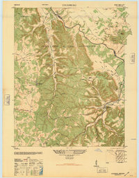
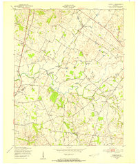
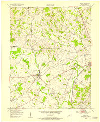 1948 Cecilia1953 Print · USGSRailroad activity dominates central Hardin County just after the war, as two major lines intersect at the junction in Cecilia. Local historians can trace established community hubs like Rineyville, find the St Johns Ch, and locate the Bethlehem Academy campus.
 - 1949 Map of Sonora, 1952 Print
 1949 Sonora1952 Print · USGSCentral Kentucky's rural landscape comes alive in the late 1940s as the railroad connects small farm towns and mill sites. Genealogists can trace family names at St. Ignatius Ch, Little Zion Ch, or the small community at Star Mills.
 - 1949 Map of Constantine, 1952 Print
 1949 Constantine1952 Print · USGSWestern Hardin County and neighboring Breckinridge County are captured here in the late 1940s, showing a landscape of ridge-top farms and valley schools. Researchers can find family-named landmarks like Pierce Mill, Grandview Ch, and Pole Bridge Sch.
 - 1949 Map of Tonieville, 1952 Print
 1949 Tonieville1952 Print · USGSLarue and Hardin counties appear here at the close of the 1940s, showing a rural landscape anchored by the Nolin River. Genealogists can trace family footprints through sites like Siberia Sch, St Anthonys Ch, and the settlement at Eagle Mills.
 - 1949 Map of Summit, 1952 Print
 1949 Summit1952 Print · USGSHardin and Grayson Counties are seen here in the late Forties, defined by the winding Nolin River and the rural railroad corridor. Genealogists and local historians can trace family-named sites like Horns Place, the Duncan Cem, and Webb Mills.
 - 1949 Map of Howe Valley, 1952 Print
 1949 Howe Valley1952 Print · USGSMid-century Hardin County, Kentucky, reveals a rural landscape of scattered hamlets and family-named landmarks just after the war. Local researchers can trace the locations of Howe Valley Ch, the Blueball Quarry, and early education sites like New Union Sch.
 - 1949 Map of Big Clifty, 1952 Print
 1949 Big Clifty1952 Print · USGSMid-century Grayson County comes to life in this detailed survey of the central Kentucky uplands during the postwar years. Local historians can trace the Illinois Central line through Big Clifty or locate ancestral sites like Smith Chapel and the Ford Sch.
 - 1949 Map of Elizabethtown, 1952 Print
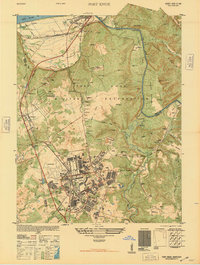
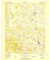
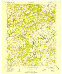
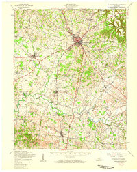
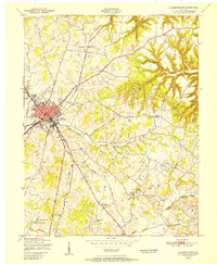 1949 Elizabethtown1952 Print · USGSPost-war Hardin County is centered on the railroad junction at Elizabethtown as the regional economy transitioned into the late 1940s. Genealogists can locate family landmarks like Helm Cem, Chestnut Grove Sch, and Locust Grove Ch.
 - 1949 Map of Shepherdsville, 1959 Print
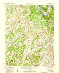
 1949 Shepherdsville1959 Print · USGSBullitt and Nelson counties are shown here in the late 1940s, a landscape shaped by the Salt River and the expanding Bernheim Forest. Researchers can trace rural life through old schools like Woodsdale Sch and the rail-side activity at Bardstown Junction.
 - 1949 Map of Big Clifty, 1959 Print
 1949 Big Clifty1959 Print · USGSThe rural communities of Grayson and Hardin counties are captured in the late 1940s, a time when small schoolhouses and country churches still anchored local life. Researchers can trace family roots at St Elizabeth Cem or locate long-standing landmarks like Pierce Mill and the Needham Chapel Ch along the Rough River.
 - 1949 Map of Elizabethtown, 1959 Print
 1949 Elizabethtown1959 Print · USGSHardin and LaRue Counties are captured here in the late Forties, showing a landscape defined by the intersection of major rail lines and rural community life. Genealogists can locate numerous country schools and churches, including Bethlehem Academy, St Johns Ch, and Glendale Sch.
End of results
Showing maps 1-21 of 21
Top cities of Hardin County
- Elizabethtown historical maps
- Radcliff historical maps
- Vine Grove historical maps
- Rineyville historical maps
- Sonora historical maps
Frequently asked questions
- What are the different types of historical maps available for Hardin County?
- What is the oldest map of Hardin County?
- Where can I purchase historical maps of Hardin County for my home or office?
- Where can I download high-res historical maps of Hardin County?
- Are there historical topographic maps available for Hardin County?
- Is there historical aerial imagery available for Hardin County?
- Where are historical maps of Hardin County sourced from?