1990s Maps of Vine Grove, Kentucky
Explore 3 historic maps of Vine Grove from the 1990s. These maps offer a rare glimpse into what life looked like during the 1990s — showing old roads, neighborhoods, homes, and landmarks that have changed or disappeared over time.
Whether you're researching your family's past, planning a metal detecting trip, or studying how Vine Grove's landscape evolved across the 1990s, these high-resolution maps are a powerful tool for exploring the history of this region.
- Focus on a specific era: All maps on this page are from the 1990s, giving you a focused view of this time period.
- See what’s changed: Compare century-old streets, trails, and buildings to today's modern landscape using overlays and satellite layers.
- Research with precision: Use these maps for genealogy, historical research, land use analysis, or educational projects.
- View, download, or print: Maps are fully viewable online in high resolution, and can be downloaded or printed for your own records.
Start exploring Vine Grove's history through authentic maps from the 1990s. This is your window into the past.
Vine Grove, KY maps
(3)- 1991 Map of Tell City
 1991 Tell City1991 Print · USGSThe Ohio River valley at the start of the nineties reveals a landscape of riverfront industry and sprawling conservation lands. Genealogists can locate family landmarks like Wesley Chapel and rural communities such as Reynolds Station and Maceo.
 - 1991 Map of Flaherty, 1992 Print
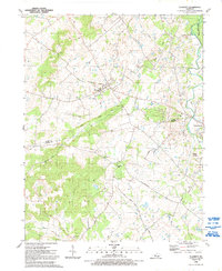 1991 Flaherty1992 Print · USGSThe rural borders of Meade and Hardin Counties are captured here in the early nineties, where the Fort Knox Military Reservation meets local farmland. Researchers can trace numerous family burial sites and country churches, including Swan Cem, Tarplay Cem, and Hilltop Ch.
 - 1991 Map of Vine Grove, 1992 Print
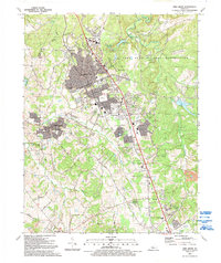 1991 Vine Grove1992 Print · USGSRadcliff and Vine Grove appear at a moment of significant residential growth in the early nineties, bordered by the federal lands of Fort Knox. Researchers can trace family roots at Stovall Ch, Stanton Cem, and old settlements like Rogersville.
End of results
Showing maps 1-3 of 3
Top cities near Vine Grove
- Louisville historical maps
- Elizabethtown historical maps
- Radcliff historical maps
- Rineyville historical maps
- Brandenburg historical maps
- Ekron historical maps
See more
Frequently asked questions
- What are the different types of historical maps available for Vine Grove?
- What is the oldest map of Vine Grove?
- Where can I purchase historical maps of Vine Grove for my home or office?
- Where can I download high-res historical maps of Vine Grove?
- Are there historical topographic maps available for Vine Grove?
- Is there historical aerial imagery available for Vine Grove?
- Where are historical maps of Vine Grove sourced from?