1950s Maps of Bonnieville, Kentucky
Explore 3 historic maps of Bonnieville from the 1950s. These maps offer a rare glimpse into what life looked like during the 1950s — showing old roads, neighborhoods, homes, and landmarks that have changed or disappeared over time.
Whether you're researching your family's past, planning a metal detecting trip, or studying how Bonnieville's landscape evolved across the 1950s, these high-resolution maps are a powerful tool for exploring the history of this region.
- Focus on a specific era: All maps on this page are from the 1950s, giving you a focused view of this time period.
- See what’s changed: Compare century-old streets, trails, and buildings to today's modern landscape using overlays and satellite layers.
- Research with precision: Use these maps for genealogy, historical research, land use analysis, or educational projects.
- View, download, or print: Maps are fully viewable online in high resolution, and can be downloaded or printed for your own records.
Start exploring Bonnieville's history through authentic maps from the 1950s. This is your window into the past.
Bonnieville, KY maps
(3)- 1953 Map of Munfordville, 1955 Print
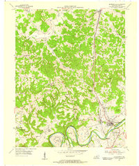 1953 Munfordville1955 Print · USGSMid-century Hart County centers on the vital river crossing at Munfordville as the regional economy shifts between rail and highway. Local historians can trace family sites like Puckett Cem, the Euclid Sch, and the Civil War Monument.2 unique versions available
 - 1954 Map of Upton, 1955 Print
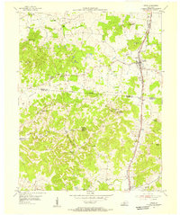 1954 Upton1955 Print · USGSCentered on the Hardin and Hart county line in the mid-fifties, this area shows a landscape of rail-linked towns and karst springs. Researchers can trace family history through sites like Lucas Grove Ch, Upton Cem, and the old mill at Riders Mill.
 - 1957 Map of Winchester, 1968 Print
 1957 Winchester1968 Print · USGSCentral Kentucky's landscape in the mid-twentieth century features the sprawling Fort Knox and the early parkway system. Genealogists and historians can trace rail lines like the Southern Railway and find landmarks from Bernheim Forest to Pilot Knob.3 unique versions available
End of results
Showing maps 1-3 of 3
Top cities near Bonnieville
- Hodgenville historical maps
- Cave City historical maps
- Horse Cave historical maps
- Munfordville historical maps
- Sonora historical maps
Frequently asked questions
- What are the different types of historical maps available for Bonnieville?
- What is the oldest map of Bonnieville?
- Where can I purchase historical maps of Bonnieville for my home or office?
- Where can I download high-res historical maps of Bonnieville?
- Are there historical topographic maps available for Bonnieville?
- Is there historical aerial imagery available for Bonnieville?
- Where are historical maps of Bonnieville sourced from?