1960s Maps of Lewis County, Kentucky
Explore 9 historic maps of Lewis County from the 1960s. These maps offer a rare glimpse into what life looked like during the 1960s — showing old roads, neighborhoods, homes, and landmarks that have changed or disappeared over time.
Whether you're researching your family's past, planning a metal detecting trip, or studying how Lewis County's landscape evolved across the 1960s, these high-resolution maps are a powerful tool for exploring the history of this region.
- Focus on a specific era: All maps on this page are from the 1960s, giving you a focused view of this time period.
- See what’s changed: Compare century-old streets, trails, and buildings to today's modern landscape using overlays and satellite layers.
- Research with precision: Use these maps for genealogy, historical research, land use analysis, or educational projects.
- View, download, or print: Maps are fully viewable online in high resolution, and can be downloaded or printed for your own records.
Start exploring Lewis County's history through authentic maps from the 1960s. This is your window into the past.
Lewis County, KY maps
(9)- 1960 Map of Huntington
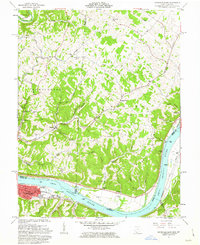
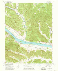
 1960 Huntington1960 Print · USGSThe tri-state river valley thrived in the late fifties as a hub of heavy industry and Appalachian rail transit. Genealogists and historians can trace the connection between river towns like Ashland and Portsmouth or locate family homesteads near Coleman Ridge.
 - 1961 Map of Maysville East, 1963 Print
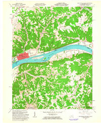
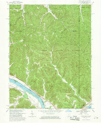
 1961 Maysville East1963 Print · USGSThe Ohio River valley and the Kentucky-Ohio border come into focus in this early 1960s survey. Genealogists can trace local roots through numerous family and church landmarks like Hiett Chapel Cem, Ravenscroft Chapel, and the community at Beetle.4 unique versions available
 - 1961 Map of Manchester Islands, 1963 Print
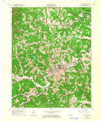
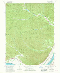
 1961 Manchester Islands1963 Print · USGSThe Ohio River valley at the start of the sixties reveals a landscape shaped by river commerce and the Chesapeake and Ohio railroad. Trace family roots and local history through the streets of Manchester or rural landmarks like Quinn Chapel and Bentonville Cem.4 unique versions available
 - 1962 Map of Olive Hill, 1964 Print
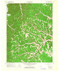
 1962 Olive Hill1964 Print · USGSOlive Hill and the surrounding rural hollows of Carter County are shown in detail during the early 1960s. Researchers can trace the path of the Chesapeake and Ohio railroad through old communities like Lawton and Globe.
 - 1962 Map of Wesleyville, 1964 Print
 1962 Wesleyville1964 Print · USGSNortheastern Kentucky in the early sixties was a landscape of deep hollows and iron industry remnants. Researchers can trace family sites like Sexton Cem, old communities such as Wesleyville, and the historic industrial site at Boone Furnace.2 unique versions available
 - 1967 Map of Buena Vista, 1969 Print
 1967 Buena Vista1969 Print · USGSThe Ohio River valley near the Scioto and Adams county line shows a landscape of deep timbered hollows and riverside rail life in the late sixties. Researchers can trace the path of the Chesapeake and Ohio railroad or locate local landmarks like Quick Run Chapel and the Twin Creek Lookout Tower.2 unique versions available
 - 1967 Map of Concord, 1969 Print
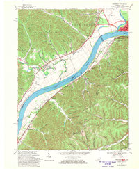
 1967 Concord1969 Print · USGSThe Ohio River borderlands between Kentucky and Ohio are captured here in the late sixties, showing the vital river-and-rail corridor. Researchers can trace rural life via Chalkley Station, Beasley Fork Chapel, and family-named sites like Mefford Hol.3 unique versions available
 - 1967 Map of Pond Run, 1970 Print
 1967 Pond Run1970 Print · USGSThe Ohio River hills and the deep valleys of the Shawnee State Forest are recorded here in the late sixties. Researchers can trace the quiet reaches of Turkey Creek and locate family landmarks like McDermott Cem and McKendree Ch.3 unique versions available
 - 1968 Map of Friendship, 1970 Print
 1968 Friendship1970 Print · USGSThe Ohio River borderlands are seen here in the late sixties, where industrial valleys meet the forested ridges of Shawnee State Forest. Genealogists can trace family landmarks like Vaughters Cem, Stony Run Tabernacle, and Morris Hill Ch.3 unique versions available
End of results
Showing maps 1-9 of 9
Top cities of Lewis County
Frequently asked questions
- What are the different types of historical maps available for Lewis County?
- What is the oldest map of Lewis County?
- Where can I purchase historical maps of Lewis County for my home or office?
- Where can I download high-res historical maps of Lewis County?
- Are there historical topographic maps available for Lewis County?
- Is there historical aerial imagery available for Lewis County?
- Where are historical maps of Lewis County sourced from?