1960s Maps of Madison County, Kentucky
Explore 6 historic maps of Madison County from the 1960s. These maps offer a rare glimpse into what life looked like during the 1960s — showing old roads, neighborhoods, homes, and landmarks that have changed or disappeared over time.
Whether you're researching your family's past, planning a metal detecting trip, or studying how Madison County's landscape evolved across the 1960s, these high-resolution maps are a powerful tool for exploring the history of this region.
- Focus on a specific era: All maps on this page are from the 1960s, giving you a focused view of this time period.
- See what’s changed: Compare century-old streets, trails, and buildings to today's modern landscape using overlays and satellite layers.
- Research with precision: Use these maps for genealogy, historical research, land use analysis, or educational projects.
- View, download, or print: Maps are fully viewable online in high resolution, and can be downloaded or printed for your own records.
Start exploring Madison County's history through authentic maps from the 1960s. This is your window into the past.
Madison County, KY maps
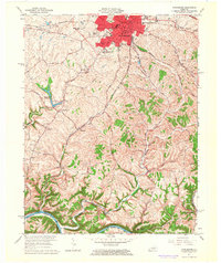
(6)- 1960 Map of Winchester
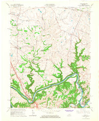
 1960 Winchester1960 Print · USGSCentral Kentucky's diverse landscape is shown here at mid-century, from the bluegrass plains to the rugged Pottsville Escarpment. Genealogists and historians can trace the rail-and-river network connecting towns like Bardstown and Stanford alongside landmarks like Lake Cumberland.
 - 1965 Map of Winchester, 1966 Print
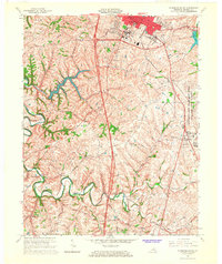
 1965 Winchester1966 Print · USGSIn the mid-1960s, Winchester was a growing regional hub defined by its historic rail junctions and new suburban estates. Researchers can locate the grounds of Southeastern Christian College, rural centers like Providence, and the winding Kentucky River.3 unique versions available
 - 1965 Map of Richmond North, 1966 Print
 1965 Richmond North1966 Print · USGSMadison County during the mid-sixties shows a landscape of established farmsteads and growing suburban fringes north of the county seat. Genealogists and local historians can trace family land near White Hall, Mt Nebo Ch, and the Daniel Boone Sch.3 unique versions available
 - 1965 Map of Coletown, 1966 Print
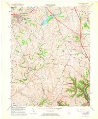 1965 Coletown1966 Print · USGSSoutheast of Lexington during the mid-sixties, this area shows the transition from suburban growth to traditional Bluegrass farm country. Genealogists can locate family sites near Walnut Hill Ch, Coletown, and the Todds Cem.5 unique versions available
 - 1965 Map of Richmond South, 1967 Print
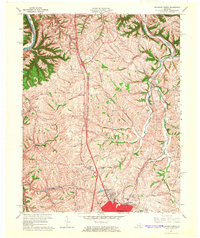
 1965 Richmond South1967 Print · USGSMadison County's landscape in the mid-sixties shows the growing city of Richmond alongside the massive Lexington-Blue Grass Army Depot. Local historians can trace old community hubs like Peytontown, Crooksville, and the campus of Eastern Kentucky University.3 unique versions available
 - 1965 Map of Ford, 1967 Print
 1965 Ford1967 Print · USGSThe Kentucky River corridor south of Winchester comes alive in the mid-1960s as a hub of river crossings and small Bluegrass hamlets. Researchers can trace family sites and local landmarks like Clays Ferry, Durbin Memorial Ch, and Niblicktown.2 unique versions available
End of results
Showing maps 1-6 of 6
Top cities of Madison County
Frequently asked questions
- What are the different types of historical maps available for Madison County?
- What is the oldest map of Madison County?
- Where can I purchase historical maps of Madison County for my home or office?
- Where can I download high-res historical maps of Madison County?
- Are there historical topographic maps available for Madison County?
- Is there historical aerial imagery available for Madison County?
- Where are historical maps of Madison County sourced from?