1990s Maps of Grahamton, Kentucky
Explore 3 historic maps of Grahamton from the 1990s. These maps offer a rare glimpse into what life looked like during the 1990s — showing old roads, neighborhoods, homes, and landmarks that have changed or disappeared over time.
Whether you're researching your family's past, planning a metal detecting trip, or studying how Grahamton's landscape evolved across the 1990s, these high-resolution maps are a powerful tool for exploring the history of this region.
- Focus on a specific era: All maps on this page are from the 1990s, giving you a focused view of this time period.
- See what’s changed: Compare century-old streets, trails, and buildings to today's modern landscape using overlays and satellite layers.
- Research with precision: Use these maps for genealogy, historical research, land use analysis, or educational projects.
- View, download, or print: Maps are fully viewable online in high resolution, and can be downloaded or printed for your own records.
Start exploring Grahamton's history through authentic maps from the 1990s. This is your window into the past.
Grahamton, KY maps
(3)- 1991 Map of Tell City
 1991 Tell City1991 Print · USGSThe Ohio River valley at the start of the nineties reveals a landscape of riverfront industry and sprawling conservation lands. Genealogists can locate family landmarks like Wesley Chapel and rural communities such as Reynolds Station and Maceo.
 - 1991 Map of Rock Haven, 1992 Print
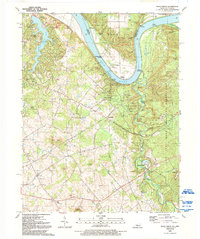 1991 Rock Haven1992 Print · USGSMeade County sits at the edge of the Ohio River in the early nineties, where industrial gas storage meets expansive parklands. Genealogists and historians can trace family plots like Johnston Cem or locate the historic Doe Run Mill and the riverfront at Rock Haven.
 - 1998 Map of Rock Haven, 2001 Print
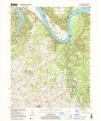 1998 Rock Haven2001 Print · USGSMeade County and the Ohio River shoreline appear at a point of intersection between industrial heritage and military expansion in the late nineties. Genealogists and historians can trace family landings like Hughes Landing and Cedar Farm Landing or locate vanished sites like Grahamton and Doe Run Mill.
End of results
Showing maps 1-3 of 3
Top cities near Grahamton
- Louisville historical maps
- Elizabethtown historical maps
- Radcliff historical maps
- Vine Grove historical maps
- Rineyville historical maps
- Brandenburg historical maps
See more
Frequently asked questions
- What are the different types of historical maps available for Grahamton?
- What is the oldest map of Grahamton?
- Where can I purchase historical maps of Grahamton for my home or office?
- Where can I download high-res historical maps of Grahamton?
- Are there historical topographic maps available for Grahamton?
- Is there historical aerial imagery available for Grahamton?
- Where are historical maps of Grahamton sourced from?