1970s Maps of Todd County, Kentucky
Explore 4 historic maps of Todd County from the 1970s. These maps offer a rare glimpse into what life looked like during the 1970s — showing old roads, neighborhoods, homes, and landmarks that have changed or disappeared over time.
Whether you're researching your family's past, planning a metal detecting trip, or studying how Todd County's landscape evolved across the 1970s, these high-resolution maps are a powerful tool for exploring the history of this region.
- Focus on a specific era: All maps on this page are from the 1970s, giving you a focused view of this time period.
- See what’s changed: Compare century-old streets, trails, and buildings to today's modern landscape using overlays and satellite layers.
- Research with precision: Use these maps for genealogy, historical research, land use analysis, or educational projects.
- View, download, or print: Maps are fully viewable online in high resolution, and can be downloaded or printed for your own records.
Start exploring Todd County's history through authentic maps from the 1970s. This is your window into the past.
Todd County, KY maps
(4)- 1972 Map of Kirkmansville, 1973 Print
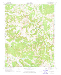 1972 Kirkmansville1973 Print · USGSThe borderlands of Muhlenberg and Todd counties are captured here in the 1970s, showing a landscape defined by the Pond River and small-town Kentucky life. Genealogists can trace family names at the Lear Cemetery and Sears Horse Cemetery, or locate the Landmark Assembly Ch in the hills.2 unique versions available
 - 1972 Map of Haleys Mill, 1973 Print
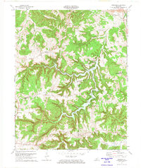
 1972 Haleys Mill1973 Print · USGSNorthern Christian County was a landscape of small farming communities and growing oil fields in the early 1970s. Genealogists can locate family landmarks like Atkinson Cem and Johnston Cem or trace early roads near Haleys Mill and Apex.2 unique versions available
 - 1972 Map of Rosewood, 1974 Print
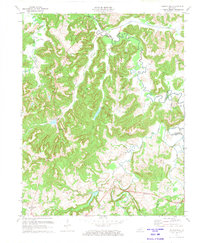
 1972 Rosewood1974 Print · USGSThe tri-county border area of Muhlenberg, Todd, and Logan counties is captured here in the early seventies as recreation and rural life meet. Genealogists and local historians can trace family sites at Tyewhoppety, Mays Store, and Myers Chapel.
 - 1974 Map of Trenton, 1976 Print
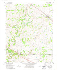 1974 Trenton1976 Print · USGSThe Kentucky-Tennessee borderlands in the mid-1970s reveal a landscape of river-bend farms and rail-dependent towns. Researchers can locate family landmarks such as Woodward Cem, the community of Barkers Mill, and rural sites like Pisgah Ch and Trenton.
End of results
Showing maps 1-4 of 4
Top cities of Todd County
Frequently asked questions
- What are the different types of historical maps available for Todd County?
- What is the oldest map of Todd County?
- Where can I purchase historical maps of Todd County for my home or office?
- Where can I download high-res historical maps of Todd County?
- Are there historical topographic maps available for Todd County?
- Is there historical aerial imagery available for Todd County?
- Where are historical maps of Todd County sourced from?