1930s Maps of Trimble County, Kentucky
Explore 3 historic maps of Trimble County from the 1930s. These maps offer a rare glimpse into what life looked like during the 1930s — showing old roads, neighborhoods, homes, and landmarks that have changed or disappeared over time.
Whether you're researching your family's past, planning a metal detecting trip, or studying how Trimble County's landscape evolved across the 1930s, these high-resolution maps are a powerful tool for exploring the history of this region.
- Focus on a specific era: All maps on this page are from the 1930s, giving you a focused view of this time period.
- See what’s changed: Compare century-old streets, trails, and buildings to today's modern landscape using overlays and satellite layers.
- Research with precision: Use these maps for genealogy, historical research, land use analysis, or educational projects.
- View, download, or print: Maps are fully viewable online in high resolution, and can be downloaded or printed for your own records.
Start exploring Trimble County's history through authentic maps from the 1930s. This is your window into the past.
Trimble County, KY maps
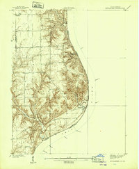
(3)- 1932 Map of La Grange
 1932 La Grange1932 Print · USGSThe Bluegrass region in the early thirties reveals a landscape defined by the Louisville and Nashville Railroad and the Ohio River. Genealogists can locate family landmarks like Henrysville Cemetery and several rural schoolhouses including Sweeney Sch.
 - 1939 Map of Bethlehem
 1939 Bethlehem1939 Print · USGSSouthern Indiana river life and upland farming are frozen in time just before the war. Genealogists and local historians can trace family roots through markers like Turner Cem, Elizabeth Ch, and the rural Fairview Sch.2 unique versions available
 - 1939 Map of Madison West
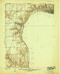 1939 Madison West1939 Print · USGSThe river bluffs of Jefferson County are captured here just before the Second World War, showing the steep topography of the Ohio River valley. Researchers can trace local landmarks like Hanover College, Clifty Falls State Park, and rural sites like Antioch Grange.3 unique versions available
End of results
Showing maps 1-3 of 3
Top cities of Trimble County
Frequently asked questions
- What are the different types of historical maps available for Trimble County?
- What is the oldest map of Trimble County?
- Where can I purchase historical maps of Trimble County for my home or office?
- Where can I download high-res historical maps of Trimble County?
- Are there historical topographic maps available for Trimble County?
- Is there historical aerial imagery available for Trimble County?
- Where are historical maps of Trimble County sourced from?