1940s Maps of Trimble County, Kentucky
Explore 3 historic maps of Trimble County from the 1940s. These maps offer a rare glimpse into what life looked like during the 1940s — showing old roads, neighborhoods, homes, and landmarks that have changed or disappeared over time.
Whether you're researching your family's past, planning a metal detecting trip, or studying how Trimble County's landscape evolved across the 1940s, these high-resolution maps are a powerful tool for exploring the history of this region.
- Focus on a specific era: All maps on this page are from the 1940s, giving you a focused view of this time period.
- See what’s changed: Compare century-old streets, trails, and buildings to today's modern landscape using overlays and satellite layers.
- Research with precision: Use these maps for genealogy, historical research, land use analysis, or educational projects.
- View, download, or print: Maps are fully viewable online in high resolution, and can be downloaded or printed for your own records.
Start exploring Trimble County's history through authentic maps from the 1940s. This is your window into the past.
Trimble County, KY maps
(3)- 1943 Map of Brooksburg
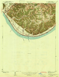 1943 Brooksburg1943 Print · USGSJefferson and Switzerland counties meet along the Ohio River in this early 1940s survey of the Indiana-Kentucky border. Trace the river-based economy and rural transit of the era through the Carrollton Ferry and family landmarks like Mc Kay Cem and McKay Sch.
 - 1948 Map of Bethlehem
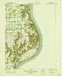 1948 Bethlehem1948 Print · USGSThe Indiana-Kentucky borderlands along the great bend of the Ohio River appear here in the late thirties. Local historians can trace the foundations of riverside life at Bethlehem and Miles Point, or find family-named landmarks like Turner Cem and Elizabeth Ch.2 unique versions available
 - 1948 Map of Madison West
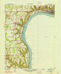 1948 Madison West1948 Print · USGSThe river bluffs of Jefferson County are captured here in the late 1930s, showing the early development of Clifty Falls State Park and Hanover College. Researchers can trace the Pennsylvania railroad tracks or locate early landmarks like Antioch Grange and Springdale Cem.2 unique versions available
End of results
Showing maps 1-3 of 3
Top cities of Trimble County
Frequently asked questions
- What are the different types of historical maps available for Trimble County?
- What is the oldest map of Trimble County?
- Where can I purchase historical maps of Trimble County for my home or office?
- Where can I download high-res historical maps of Trimble County?
- Are there historical topographic maps available for Trimble County?
- Is there historical aerial imagery available for Trimble County?
- Where are historical maps of Trimble County sourced from?