1940s Maps of Union County, Kentucky
Explore 4 historic maps of Union County from the 1940s. These maps offer a rare glimpse into what life looked like during the 1940s — showing old roads, neighborhoods, homes, and landmarks that have changed or disappeared over time.
Whether you're researching your family's past, planning a metal detecting trip, or studying how Union County's landscape evolved across the 1940s, these high-resolution maps are a powerful tool for exploring the history of this region.
- Focus on a specific era: All maps on this page are from the 1940s, giving you a focused view of this time period.
- See what’s changed: Compare century-old streets, trails, and buildings to today's modern landscape using overlays and satellite layers.
- Research with precision: Use these maps for genealogy, historical research, land use analysis, or educational projects.
- View, download, or print: Maps are fully viewable online in high resolution, and can be downloaded or printed for your own records.
Start exploring Union County's history through authentic maps from the 1940s. This is your window into the past.
Union County, KY maps
(4)- 1949 Map of Paducah
 1949 Paducah1949 Print · USGSThe confluence of the Ohio, Mississippi, Tennessee, and Cumberland rivers at the close of the 1940s reveals a region bound by water and rail. Researchers can trace historic river landings, timberlands in the Shawnee National Forest, and the coal-mining infrastructure around West Frankfort and Herrin.2 unique versions available
 - 1949 Map of New Haven, 1958 Print
 1949 New Haven1958 Print · USGSSouthern Illinois and the Indiana borderlands are captured here in the late 1940s, highlighting the intricate river-and-rail landscape at the confluence of the Wabash and Ohio. Genealogists and historians can trace old homesteads and post offices like Concord Emma PO, Ridgway, and New Haven.
 - 1949 Map of Morganfield, 1966 Print
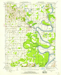
 1949 Morganfield1966 Print · USGSMorganfield and the surrounding Union County countryside are documented here during the post-war era as military activity and resource extraction shaped the land. Genealogists can locate numerous family burial grounds including Waller Cem and Sugg Cem, alongside landmarks like Antioch Ch.
 - 1949 Map of Poole, 1967 Print
 1949 Poole1967 Print · USGSKentucky's tri-county borderlands come into focus in the late 1940s, showing a landscape defined by military land use and the Illinois Central railroad. Genealogists can locate numerous family-named burial sites like Liles Cem and Sisk Cem near the Camp Breckinridge Military Reservation.
End of results
Showing maps 1-4 of 4
Top cities of Union County
Frequently asked questions
- What are the different types of historical maps available for Union County?
- What is the oldest map of Union County?
- Where can I purchase historical maps of Union County for my home or office?
- Where can I download high-res historical maps of Union County?
- Are there historical topographic maps available for Union County?
- Is there historical aerial imagery available for Union County?
- Where are historical maps of Union County sourced from?